Sea Adventure

Pen and ink drawing of ship with sails flying in billowing waves under the drak promontory with the Abbey drawn in black.
Sailing ship under Whitby Abbey in stormy conditions, Charles George Harper.
Source: Historic England Archive

A Sturdy Whitby Collier in the Storm of November 1810

It is my pleasure to welcome Mike Salter as our guest blogger for this article, which combines the old and new meanings of the word ‘adventure’: the shipwreck adventure of a vessel named the Sea Adventure, highlighted on the 300th anniversary of her build in 1724.

At that time the word ‘adventure’ meant a commercial venture, so a shipowner would ‘adventure’ his capital on the sea (although the modern word ‘venture’ was also commonly used). This naturally led to the meaning of ‘risk’, which has segued into today’s modern meaning, an exciting and/or risky activity or event. These two elements are present in her story, which Mike has researched and compiled into a booklet (details below).

He distils his research into the Sea Adventure‘s life and times below:

Her Life: Whitby and the Collier Trade

Colliers were the workhorses of the Industrial Revolution, bringing millions of tons of coal from the coalfields of the North-East to London and the east coast ports such as (King’s) Lynn, (Great) Yarmouth and Ipswich. Overlooked by many, they nevertheless fuelled British economic growth and overseas expansion.

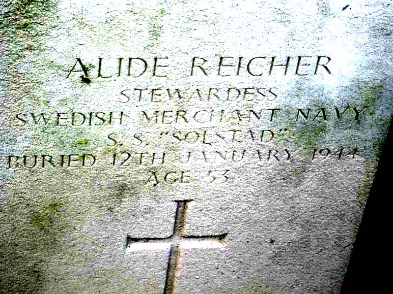
My interest in the Sea Adventure stemmed from finding out more about the loss of King John’s regalia in the Wash, leading to finding out about a buried medieval bridge in Holbeach [1], Holbeach as a minor port and the wreck of a ship on Holbeach Marsh in November 1810. [2] (It was this research detailing her cargoes, masters, voyages and events during her lifetime that led to the booklet!)

Initial reports named her as the Sea Venture, a 100-year-old Whitby collier built in the reign of Queen Anne (1702-14). Both her name and age proved to be incorrect. Sea Adventure was her correct name [3], and a Jarvis Coates built her in his Whitby yard in 1724 under George I. [4] This year of 2024 is therefore the tercentenary of her construction.

George Young in his 1817 History of Whitby wrote, while the ship was still in recent memory:

”The strength and durability of the Whitby ships may be inferred from the great age some of them have attained. The Sea Adventure is a noted instance; that vessel braved the storms of 86 years, having been built in 1724 and lost in 1810; nor did she go to pieces even at the last , but was carried up by the violence of the wind and of the flood tide into the midst of a field, where she was left high and dry, a good way from the sea on the coast of Lincolnshire.”

The construction of Sea Adventure was that of a ‘cat’ collier with round bluff bows, a deep waist and ‘pinked’ or tapering at the stern. The Earl of Pembroke which became Captain Cook’s Endeavour was such a ship, all of which were built more than 40 years after Sea Adventure, in Whitby. To the disgust of some, he chose these ships over sleeker vessels as they were robust, seaworthy and easily repaired on shore, especially in exotic parts. [5]

Historic black & white engraving of a three-masted ship heeled over for repair in the river with people in boats inspecting the ship's bottom, and anchors, casks and ropes visible in the foreground.
Print c.1780 depicting Cook’s Endeavour badly damaged and under repair after running aground on the Great Barrier Reef in June 1770 (his first voyage). © National Maritime Museum, Greenwich, London

Whitby was a bustling port in the 18th and 19th centuries [6], building many ships for its shipowners and for those of many other ports. It was the seventh largest ship building port in the UK. Many ships were employed on the North Sea and Baltic routes. These were treacherous, with severe storms, rocks, sandbanks, and the threat of pirates and the press gangs. [7] R Weatherill counted more than 400 ships off Whitby at one time, with many from the north-east. He was also told that up to 800 would arrive in the Thames on one tide if there was a favourable wind.  It is no wonder there were often collisions both in port and on the open sea. [8]

Scan of historic black & white print of a busy harbour scene, with tall sailing ships coming and going, and moored, all along the left of image, small rowing boats criss-crossing the harbour, and to right quayside houses and people promenading along the quay
Whitby Harbour scene, by permission of the Whitby Literary & Philosophical Society

In 1794, during the war with France, Whitby was deemed important enough to warrant fortification against attack from seawards . There were also seamen’s strikes in Shields, broken up by the Royal Navy. Some colliers including Sea Adventure, sailed the Baltic routes.

It is interesting to note the fact that the French and Dutch navies were collaborating from 1786 onwards in the fortification of Cherbourg as a port from which to safeguard the Channel, keep a watchful eye on England’s main naval base of Portsmouth, and potentially attack England. [9]

Late 18th century pen and ink plan of the harbour addressed to the Right Honourable Henry Lord Mulgrave, with textual observations to left and a topographical view of the entrance to the harbour below.
Francis Gibson’s plan for the defences of Whitby, c1794, with Board of Ordnance ‘broad arrow’ stamp. A version of this map exists in North Yorkshire archives, with two significant differences: the defences of the Half Moon Battery, unspecified in this version, are shown in the North Yorkshire version, with 12 x 18pdrs en barbette and a ‘bomb-proof’ magazine, while the ships shown here ‘running inshore for shelter’ have grounded for ‘want of tide to carry them into harbour’ in the other version. Both versions show the line of fire afforded to an ‘enemy ship’ approaching Whitby (marked in red here).
MP/WHA0096 Source Historic England Archive

Her (Very Long) Times – the longevity of ships

Sea Adventure was not unique in being lost at 86 years of age as there were several vessels which operated over 100 years.

Perhaps the most famous was Betsy Cains, built in the King’s Yard in 1690 or 1699, but which had become erroneously associated with bringing over William of Orange in 1688. Her actual history was trading with the West Indies, then transfer to the London and Baltic coal routes, followed by hire as a government transport over 1808-10, during the Napoleonic Wars. On 17th February 1827 she was wrecked at around 130 years old on the notorious Black Middens rocks while leaving her home port of Shields, laden with coal for Hamburg. Many people took pieces of her venerable timbers to make snuff boxes and other souvenirs, and Orange Lodges in particular were keen to have a memento, given the mythical association with William of Orange. [10]

Liberty and Property (known in Whitby as Old Liberty and Property) was built in 1752 and sailed the East Coast and Baltic routes, remaining on the Whitby Register until 1840. Later she transferred to Shields and was eventually wrecked in 1856 in Gotland, Sweden – at 104 years old. Her goods were sold for the benefit of the underwriters. She was described as ‘being engaged in the coal, Baltic trade and transport service – a strange old-fashioned looking craft, attracting a good deal of attention in the Thames and other ports she visited.’ [11]

In 1888, the little schooner Lively ended her days wrecked on the Norfolk coast near Cromer. Built at Whitby in 1786, she was more than 100 years old at the time of loss, and was described in an advert for sale as being suitable for beach landings. The Whitby Gazette of 2nd June 1888 carried a full report and a ‘lament’ to the much-loved old ship, the last lines of which read:

When through the bridge away she glides to find her ancient moorings
Old Whitby’s ships and tars have gone, one after one in order
Yet Whitby’s sons are still the same in courage and in valour. AN OLD FRIEND.

There were other ships which may have gone on to reach their century, such as the William and Jane, built Whitby 1717, and transferred to Newcastle in 1789, or the Content’s Increase, built Whitby 1750 and sold to Newcastle in 1835.

Her demise – the wreck of Sea Adventure

‘Dreadful Storm’ is how newspapers described the weather event of 10 November 1810, when raging winds from the ESE forced many ships on shore between Whitby and Great Yarmouth. There was a minimum of 61 shipwrecks that night, with around 40 lost on the east coast. [12]

Modern colour photo of a shipwreck in a lightbulb-shaped bottle with a museum label entitled "Last Adventure"
Model of a ‘shipwreck in a bottle’: the wreck of the Sea Adventure on Holbeach Marsh in a lightbulb some 1.5km over the salt marsh. G Leach, by permission of the Whitby Literary & Philosophical Society

That was the night which saw the loss of the Sea Adventure, bound from Shields for London with coal, a southbound voyage with land to the west on the vessel’s starboard side, which, in an ESE storm simply drove her towards shore.

The label on the ‘shipwreck in a bottle’ says the Sea Adventure ‘must have been sailed goose-winged i.e. downwind with the foresails on one side of the vessel and the mainsail on the other, leaving it too late to reduce sail, which the maker recognised from a situation he had seen. Goose- or gull–winged is defined thus: on a fore-and-aft rigged vessel ‘the jib or staysail is boomed out on the opposite side to the mainsail in a following wind to present the largest possible area of sail to the wind’ (Oxford); wing and wing with a ‘sail extended on each side, as with the foresail out on one side and the mainsail on the other’ (Collins), i.e. a 180-degree angle to maximise the area of sail exposed. (This use is seen Kipling’s poem The Coastwise Lights: ‘we greet the clippers wing-and-wing that race the Southern wool’.)

It is interesting that G. Leach (the modeller) says that the same fate befell the Esk, a Whitby whaler wrecked on Redcar Sands in September 1826, while ‘running before a storm’ on her return from a season in Greenland. [13] The Esk had picked up some sailors from the Lively whaler lost in the ice and of the three sailors who survived from the Esk, one was a William Leach, carpenter’s mate (perhaps an ancestor of the model-maker?)

The label to the ‘shipwreck in a bottle’ also picks up something crucial that illustrates the impact of this storm: that the Sea Adventure was not only driven ashore, but driven a long way inshore.

Historic black and white aerial photograph, showing an expanse of marshland at low tide criss-crossed by creek to centre and top of image, with fields of cultivated land to bottom of image.
RAF photograph taken 2 December 1944 at Holbeach, showing the vast expanse of the marshland to the north. Sea Adventure was driven inshore across the fields, possibly towards the bottom left of the present image. RAF_106G_LA_67_RP_3085 Source Historic England Archive

There were comprehensive reports of the loss of Sea Adventure in the London Chronicle of the 15th November, Stamford Mercury of the 16th, Hull Packet of the 20th, and Gentleman’s Magazine, Vol. 80, Part 2, of ships wrecked or affected by this storm (described by some as a hurricane or a tempest). Of the Sea Adventure it said she was, for the first time, ‘compelled to run for Boston Deeps’ and the crew, having struggled ashore in boats, were ‘denied even the indulgence of a barn as shelter from the pelting rain’.

Her end had come in one of the most severe storms to hit the east coast of England, which centred on nearby Boston itself. The London Chronicle reports that it started raining in Boston at 7am and continued all day. The ESE wind blew hard and from 6-9pm was ‘a perfect hurricane’. This combination of the hurricane force winds with a record height of tide in Boston – some 4 inches (10cm) above any previously seen – created a tidal bore or eagre of huge potency which swept away sea bank defences flooding the low-lying land. A vessel was deposited on the Turnpike Road near Boston town centre at Black Sluice, forced by the tidal surge up the River Witham.

Many sailors and some on land lost their lives, with reports of sailors who lashed themselves to masts as their ships sank, with other ships powerless to help them. Sixteen bodies were interred at Claxby (Stamford Mercury 23rd November), nine were picked up four miles from Lynn, and many, many more drowned with more bodies washed up on every tide (Hull Packet 20th November).

The meteorological explanation for the violence of the storm is discussed in an article [13] on storm-surge flood risk in eastern England:

The third category of surge is driven off the northeast side of a slow moving deep cyclone in the southern North Sea when isobars become concentrated owing to the presence of an anticyclone to the northwest of Scotland.  Strong pressure gradients drive onshore winds directly onto the coasts of eastern England . . .

This report notes that the same climatology was associated with one of the highest ever high water levels reported at Boston, Lincs. on 10 November 1810, consistent with the loss of the Sea Adventure, the vessel deposited on the Turnpike Road at Boston, and other craft.

Extent of the storm – other ships driven ashore

The Hull Packet of 20 November reported that the Retford of Gainsborough, with coals, was driven about a mile up the Marsh near Boston. Drakard’s Stamford News of 16 November reports that on the 10th ‘a barge drifted over the sea bank near the Scalp and may now be seen in the midst of pastures, with sheep grazing around.’

Three vessels were driven up the Fossdyke Washway , towards Spalding with one, the Ann, carried half a mile into the Marsh from the Fossdyke channel.

In the same report: ‘Near Sutton Wash are two vessels thrown upon a very high marsh, so they will not be got off but by cutting to the sea.” Captain Melion of the Amity, which was driven ashore near Lynn and went to pieces (he, his wife and children struggled ashore), reported that a light collier [i.e. in ballast] was left on the ebbing of the tide in the midst of a farmyard (Hull Packet 20 November).

Some sank at sea and at least one became a hazard: a Caution was issued to ‘Masters of Coasting vessels trading to Boston, Lynn and Wisbech, that six to seven miles West by North of the Sutton-on-Sea signal point the Masts of a Brig were above sea level on all but the highest Spring tides.’

Overall, most ships had a lifespan of 20-40 years, but relatively few ships were got off if driven hard into the rocks, sandbanks or shore, and even fewer which were deposited ‘high and dry’, as these ships were. Whatever their age, luck seems to have run out in the end.

After the wreck of Sea Adventure

Confusion over ship’s names, many having the same name, even from the same port, is not surprising and plays its part in the Sea Adventure story. Many ships were called Adventure, others Sea Venture (as Sea Adventure was in some early records) and the storm reports in papers.

But this was compounded by the fact that a ship Adventure, master Bullock, was wrecked on the same day, 10 November 1810, at Ingoldmells, north of Boston. Both ships were sold at auction but one advertisement for the later sale of the Adventure on 28 December, on the shore, referred to the Sea Adventure. Both vessels would have been broken up in situ and it is interesting to note that Sea Adventure carried 17 keels of Tanfield Moor coal (from the Durham coalfield) and was also armed, as guns were sold.

From the mid-18th century merchant ships of any size had been advised to carry arms to deter privateers. These were relatively light armaments, but in 1757 the Ann of Shields, carrying 5 guns and 8 men, saw off a French privateer of 14 guns, after a four-hour engagement. There were many other examples of successful defence; Captain Humble of the Milburn, North Shields, with 4 x 4-pounders and 13 men fought off a French schooner with 14 guns (Sun, London, 6 January 1801).                                      

Then there was La Modeste, lost in the same storm as the Sea Adventure, but this is an interesting story in its own right and is a blog for another day . . .

Modern colour close-up view of 'shipwreck in a bottle' showing the structure of the vessel and the build up of glue creating the waves inside the bottle.
Close-up of ‘shipwreck in a bottle’, with a figure visible on deck. Almost submerged by the waves, the boat can just be seen by the prow. By permission of the Whitby Literary & Philosophical Society

With many thanks to Mike for his blog and we look forward to his return with the Modeste in a later blog, and we would also like to thank the Whitby Literary and Philosophical Society for all their help and support in creating this blog.

A full description of the life and voyages of the Sea Adventure is in a booklet Sea Adventure: A Sturdy Whitby Collier 1724-1810, by M A W Salter, available from the Whitby Literary & Philosophical Society and North Yorks Archives.

Footnotes

[1] Lincolnshire Historic Environment Record MLI123637 Medieval Bridge, Holbeach

[2] Historic England Research Records maritime dataset, Sea Adventure, HOB UID 942792

[3] Sea Adventure ship’s registration 1786 & de novo 1800 (North Yorkshire Archives); Stamford Mercury, 23 November 1810, p3

[4] Cook Museum, Whitby; Gaskin, R 1909: The Old Seaport of Whitby (Whitby: Forth) p234

[5] Gaskin, op.cit.

[6] Smith, K & Keys, R 1998 Black Diamonds by Sea: North-East Sailing Colliers 1780-1880 (Newcastle: Newcastle Libraries & Information Service)

[7] Fraser, S 2023 “Documents Relating to the Official Dutch Naval Visit to Cherbourg, 8-10 September 1786”, The Mariner’s Mirror, 109:4, 461-468, DOI: 10.1080/00253359.2023.2264658

[8] Historic England’s maritime records are full of collisions in major rivers, particularly for the Thames, Humber and Mersey, as well as in the open sea, especially the North Sea, Straits of Dover, and the English Channel.

[9] Winfield, R 2005 British Warships in the Age of Sail 1793-1817 (Barnsley: Seaforth Publishing)

[10] Historic England Research Records maritime dataset, Betsy Cains, HOB UID 1031974

[11] Liverpool Mercury 11 October 1856; Weatherill, R 1908 The ancient port of Whitby and its shipping, with some subjects of interest connected therewith. Compiled from various registeres of shipping, periodicals, local newspapers and histories, etc. (Whitby: Horne) p56

[12] Historic England Research Records maritime dataset, 2024

[13] Historic England Research Records maritime dataset, HOB UID 937642

[14] Muir Wood, R, Drayton, M, Berger, A, Burgess, P, and Wright, T, 2005 “Catastrophe loss modelling of storm-surge flood risk in eastern England”, Philosophical Transactions of the Royal Society A 363: 1407–1422 DOI: http://doi.org/10.1098/rsta.2005.1575

Happy 200th Birthday RNLI!

Modern photograph of blue and white rowing boat with name Tyne painted in blue letters on white background, under a canopy with pillars in similar colours
Lifeboat Tyne, built 1833, which, together with its protective canopy, is Grade II Listed.
The master of the Norwegian brig Olaf Kyrre wrote in to a local newspaper to express his thanks to the crew of the Tyne for coming to their rescue in 1882.
© Mr A Hubbard. Source: Historic England Archive IOE01/00865/08

Today (4th March 2024) sees the 200th anniversary of the Royal National Lifeboat Institution, founded as the Royal National Institution for the Preservation of Life from Shipwreck.

That original name outlines the purpose of the institution: far too many people were being lost to shipwrecks. It was an occupational hazard of seafaring, as old as time, and our records show both that many ships went aground several times, getting off again, before finally being lost, and that individuals could likewise be shipwrecked several times in their careers with the same ship or across several ships.

The RNLI was much needed, and its foundation timely. We know that in English waters alone 220 losses were reported in 1820, 434 in 1821, 191 in 1822, 281 in 1823, and 287 in 1824. Two-thirds of those in 1824 were accounted for by two devastating storms in October and November that year, and they covered everything from small local vessels to large ocean-going ships and everything in between. Numbers of shipping losses fell back towards 171 in 1825. [1]

It’s important to say that the loss of ships and the loss of life isn’t always correlated and the purpose of the Institution was to save lives, not ships, and their foundation took place against an increasingly globalised trade which saw growing numbers of ships in English waters, in turn escalating the potential for wreck events to occur.

There are certainly events where the total loss of a ship also entails the loss of all hands – particularly where the vessel founders at sea, or gets into a very difficult position at the base of a cliff or upon dangerous rocks which make rescue nearly impossible. Sometimes, though, a vessel might go to pieces but all hands be saved. The inbound liner Suevic was wrecked off the Lizard in 1907 and to this day remains the RNLI’s biggest rescue, with over 500 crew and passengers successfully rescued, no-one being left behind. Her aft section was salvaged in the end, and rebuilt with a new bow, but the remains of her original bow still lie on the rocks from which the lifeboatmen rescued all hands over a hundred years ago.

Historic black & white photo of library on board ship, with heavy wooden chairs and desks and lit from above by a skylight cut into the deck above.
Reading Room, SS Suevic, photographed in 1901, 6 years before the RNLI attended the wreck in 1907.
Bedford Lemere BL 16481/003 Source: Historic England Archive

Conversely, a ship might remain intact but all the crew are lost, for example, swept overboard.

The RNLI and their volunteers helped sailors and passengers beat those odds, and they built on past efforts to improve the lot of the seafarer: from the lighthouses and light vessels operated by Trinity House that either warned ‘keep away, keep away’ or signalled ‘here is the safe light that guides you in’ [Our blog on Trinity House’s 500th anniversary in 2014] to the efforts of local communities and individuals. Services for coastal defence – the coastguard, the preventive and revenue men who made up the anti-smuggling forces, and the sea fencibles (coastal forces for home defence) – would often go to the assistance of vessels in distress where needed.

The impulse was always to help. It was traditional for ships to assist one another in distress where they possibly could as it was always recognised that they themselves might be in need another time. In the event of a collision, the colliding ship not stopping to assist the crew of the collidee, which would normally bear the brunt of the impact, was as strongly deprecated as a hit and run would be on today’s roads.

There were local boatmen who would always go to the assistance of others in various places, sometimes as a result of pilotage work, such as the Scillonian gigs and the Deal boatmen, a difficult and dangerous job: half the crew of a Scillonian gig were drowned going to the rescue of the Mary in distress in 1816, while in 1809 with the sea ‘dashing over them mountains high’ the crews of several wrecks, including the Admiral Gardner (now a protected wreck) driven onto the Goodwin Sands ‘were all collected on the poops waiting for that relief which the Deal boatmen seemed anxious to afford them.’ [2]

Elsewhere there might be local charitable organisations: we read in 1797 that the sole survivor of the John’s Adventure was brought ashore at Bamburgh, Northumberland, ‘much swelled’, having ‘nearly lost the use of his speech, sight and limbs, but by the care of the Dispensers of Lord Crewe’s noble charity, he is happily restored’. [3]

There were also technological innovations that arose out of particular tragedies. One tragedy at the mouth of the Tyne inspired a competition to build the first self-righting lifeboat that could be kept permanently on station wherever needed. In 1789 collier Adventure was returning to her home port at Shields from London, but a northerly gale prevented her from coming into port and despite her crew’s valiant efforts to weather the storm and keep trying ‘in a most tempestuous sea’ they were unsuccessful, ‘the sea making a free passage over her’ and she was wrecked with loss of life in full view of the local population on the notorious Herd Sand. [4]

The same conditions that made it so difficult for her to come in made it equally difficult for vessels to go to the rescue: ‘ . . . the waves ran so high that no boats durst venture to the assistance of the crew . . . ‘. This became a common theme of many later rescues by the RNLI: they often made they way to stricken vessels against almost insuperable odds.

In a similar vein, Captain Manby was inspired by other wreck events to develop his rocket apparatus, which fired a line establishing a means of communication with the stricken ship close inshore, to which a thicker rope could be attached to afford a means of escape. ‘His invention of throwing a rope to a ship stranded on a lee shore [i.e. with wind and tide flowing towards the land making it very difficult to get off again] proved the certainty of its never-failing success on the Elizabeth of Plymouth’ at Great Yarmouth in 1808. [5]

Each of these individual and collective efforts incrementally aided the safety of life at sea but they were all disparate efforts, either with specific purposes or locally focused. The establishment of the RNLI turned lifesaving into a nationally cohesive effort with specialist resources, harnessing that will to help others seen over the centuries and making it possible for members of the public to contribute to their work, as they still do today. They have always worked with local resources, crews and boats and other organisations, historical and modern, in what we today would call inter-agency working, their boats crewed by sailors who had intimate knowledge of local conditions and hazards, and whose efforts were always recognised on a national basis.

The records in the Historic England database of wrecks therefore include over 1,500 wrecks attended by the RNLI since 1824. [6] Without doubt the death toll in all cases would have risen but for their involvement. For example, we learn in October 1824 that the schooner Reuben, of and for Grangemouth, from the Baltic with oats, stranded at Cheswick Sands and went to pieces. The local preventive boatman and fishermen who came to the rescue were awarded £2 each by the Institution – not everyone on board could be saved, but their attendance prevented a loss with all hands. [7]

In peace and in war the RNLI has come out to rescue crew and passengers, and over the history of this blog we have covered a variety of events they have attended. For example, the perils of the sea, of hidden dangers and high winds, were exacerbated during the two World Wars both for the rescuers and the rescued, amongst minefields and under aerial bombardment. We have twice paid tribute to the ‘greatest lifeboatman of them all’ Henry Blogg, in his rescue of the crew of the Fernebo in 1917 and the wreck of the Monte Nevoso in 1932.

It is always worth reiterating that the conditions that see ships coming to grief are the very same conditions lifeboat crews have to battle, sometimes from the opposite direction, making rescue operations extra arduous. A lee shore or high seas – or both – could mean that local lifeboats had great difficulty putting out, and it was always a race against time before a ship broke up or sank.

Sadly the rescuers could also become victims, such as in the Mexico disaster of 1886 off Southport, in which all the crew were ultimately rescued (and the ship recovered to be wrecked once more as the Valhalla) by the Lytham lifeboat, the Southport and St. Annes lifeboats having been lost while attending the same wreck.

Historic England’s records of shipwrecks have enabled us to appreciate not only the activities of the RNLI in and of themselves, but also the documentary record they have left behind.

A very typical characteristic of wreck reports over the centuries is that they vary enormously between sources, literally between viewpoints. The view of events from witnesses on land is very different from those at sea, and we frequently reconcile reports that come in from different coastal settlements that will describe the same location of loss very differently: 2 miles east of one, 3 miles west of another, for example. Conflicting testimonies are often given in Board of Trade inquiries into wreck events, particularly in the event of collision, where each side will seek to blame the other. Ships in convoy will each have a different understanding of what is going on during a convoy battle or naval engagement, each holding their own while rendering assistance to another, while unable to see the whole, widely-dispersed battlefield and individuals on those ships will similarly have a different understanding of what is happening according to their rank, station, activity and location. All of this can be exacerbated by literal fog or the ‘fog of war’.

The perceptions of rescuer and rescued will also naturally vary, but this is where the records of the RNLI come into their own for the purposes of shipwreck documentary research (as well as human and historic interest) and greatly increase our understanding of events, of timelines, weather conditions, and the disintegration of the vessel, recorded in great detail.

For example, in our recent blog on the Solstad in January 1944, it is the RNLI’s record of attendance that sheds more light on the event than official convoy records, and as these events slip out of living memory, the documentary resource they represent becomes ever more important in our understanding of archaeological remains.

The rich heritage of lifeboats can be found everywhere on the English coast – from listed lifeboat stations to memorials to those lost in ships and from lifeboats, and the archaeological remains of ships which were attended by the RNLI. Why not go to the Heritage List for England and Historic England archives using the keyword lifeboat to discover that heritage in our listed buildings, protected wrecks and photographic records, or visit the RNLI’s History pages?

Happy Birthday RNLI!

Footnotes

[1] Information from Historic England’s wreck database, 2024

[2] Widely reported in the press in these words, for example London Packet and Lloyd’s Evening Post, Friday January 27 to Monday January 30, 1809, No.6400, p2

[3] Newcastle Courant, 11 February 1797, No.6,297, p4

[4] Newcastle Advertiser, 21 March 1789, No.21, p2

[5] British Gazette and Berwick Advertiser, 12 March 1808, No.11, p3

[6] Information from Historic England’s wreck database, 2024

[7] British Gazette and Berwick Advertiser, 4 December 1824, No.884, p4

Diary of the Second World War – February 1944

LCI(S)511

Historic black and white photo of landing craft profiled in port view, showing a long, low craft and men clustered astern (to right of image)
LCI(S) 507 at sea (FL 9821) Copyright: © IWM. Original Source: http://www.iwm.org.uk/collections/item/object/205120809

In early 1944 Britain was watching and waiting. ‘Lorries and tanks kept rumbling towards the south coast, so we knew something was going to happen,’ in the words of Corporal Cant, based at RAF Ford, Sussex, describing the later spring of 1944. ‘Nobody said anything about it. But more and more of them were building up. We saw, and we knew, but we didn’t know when, and we didn’t talk about it.’

There is something of that sense of anticipation in the wreck highlighted for February 1944, LCI(S)511, Landing Craft Infantry (Small) 511, on the Channel coast facing a France that soon would be the focus of a liberation effort by just such craft. With the benefit of historical hindsight, we can say ‘soon’, but at the time it must have felt that ‘soon’ would never come: scenes such as the one below, in the countdown to D-Day, were months away.

Historic black and white photograph of several landing craft roped together in harbour, with men in military uniform gathered on their decks
Commandos of 1st Special Service Brigade aboard LCI (S) (Landing Craft Infantry (Small)) at Warsash, Southampton, 3 June 1944. (H 39041) Copyright: © IWM. Original Source: http://www.iwm.org.uk/collections/item/object/205359405

All anyone could do was watch, wait, and play their part: and only those ‘in the know’ had an overview of what was happening behind the scenes. An initial joint plan, i.e. a combined Allied plan, was issued on 1 February for the invasion, with the naval outline plan following later that month. [2]

The Landing Craft Infantry (Small), LCI(S) for short, were built 1942-3 with bullet-proof armour plating over a wooden hull structure designed by the Fairmile Marine boatbuilding company, which specialised in motor boats (the company grew out of motor manufacture). The ‘Fairmile H’ design of the LCI(S) was produced in kit form and outsourced to other small boatbuilding firms for assembly, such as Leo Robinson at Oulton Broad, Suffolk, who built LCI(S)511 and LCI(S)533. [Explore Robinson’s yard in this historic image.] Others were built on Oulton Broad by Collins and Brook Marine, and production was dispersed countrywide, both because of the small scales of the yards and for security reasons. At 110 tons, 105 feet long x 22 feet wide, they were intended to carry a complement of around 100 men (descriptions vary from 96 to 102 troops). [3]

At the same time operational bases came into being in the run-up to D-Day. From 1942 the Southwick Ship Canal on the Sussex coast between Shoreham-by-Sea and Portslade became a Combined Operations Landing Craft Base, known as the ‘stone frigate’ HMS Lizard. HMS Lizard was further developed in 1943 and by January 1944 was ‘very busy’ with both large and small landing craft. Lizard‘s vessels and personnel are known to have participated in exercises over February 1944. [4]

The former river channel of the Adur was canalised to provide a harbour free from the natural silt deposit processes that were otherwise threatening to clog up the harbour mouth. It runs parallel to the seashore, with the river and harbour mouth further west, and sloping shingle beaches on the seaward side.

Modern colour photo taken from the viewpoint of the shingle bank in the foreground and to right which encloses the canal from the sea, looking to both arms of the canal east and west, under a heavy greyish sky.
Shoreham Harbour, seen from the eastern arm, looking towards the western arm (Southwick Ship Canal). To the right of the photograph is the outlet to the sea.
© Paul Gillett, CC BY-SA 2.0 https://www.geograph.org.uk/photo/2360037

As a ship canal for both smaller and larger vessels, landing craft could be virtually hidden in plain sight, and as a USAAF air photo from April 1944 in Historic England’s collections shows, it would all appear quite innocuous, with existing buildings requisitioned to form the base, and a natural gathering place for craft.

The advantages of this location as a base were a natural seaward defence with an easily controlled harbour mouth, and on the shoreward side are sloping shingle beaches, ideal for rehearsing landings.

Modern colour photograph on a sunny day taken from a path at the top of the beach (left of image), looking down towards the beach running to the east, (centre of image) broken up by boulder breakwaters at intervals. To the right is a calm blue sea.
Beach and breakwater looking east towards Portslade in 2008.
© John Lucas CC BY-SA 2.0 https://www.geograph.org.uk/photo/1012841

The day after the Allies issued their joint plan on 1 February 1944, LCI(S)511 was beached at Portslade, Sussex, to become a total loss. [5] What happened there? There seems to have been nothing particularly unusual about the weather that day, with local readings recording a force 4 (‘moderate breeze’) at south-westerly and temperatures mild, between 49-53 degrees Fahrenheit, which would be recorded as 9-11 degrees Celsius today. [6]

We know of at least 74 other vessels that were lost in force 4 conditions in English waters since records of weather conditions at the time of loss began in the mid-19th century. They tend to have two broad characteristics: either something else happened to them, such as springing a leak, running aground or involvement in a collision, i.e. factors which are not weather-dependent and can be overwhelming in themselves; or they were small vessels, fishing smacks, yachts, cutters, barges, and so on, which could be quite disproportionately affected by weather conditions, depending on wind direction and their activity or lading at the time.

Records appear to be quite brief, but it is possible to read between the lines a little. The key word is that LCI(S)511 was beached. There are only two reasons for beaching vessels, i.e. to deliberately put them ashore: the first, and more benign, reason, is that they can be effectively ‘parked’, as sailing colliers once did to deliver their coal on the Sussex coast, or fishing boats can still be seen today drawn up on the foreshore in many places – and, of course, beaching was what landing craft were designed to do!

As we have seen, much of the Sussex coast, as at Portslade, comprises a gently sloping shingle shoreline, ideal for beaching vessels, and this history of safe landing grounds was what fitted Portslade and Shoreham on either side of the Adur to be a landing craft base.

However, beaching on the foreshore can leave the craft so drawn up very vulnerable if a storm subsequently ensues. In other words, they can be safely beached, then lost after beaching, but this seems unlikely in the weather conditions reported for 2 February 1944. With the beach ideal for the landing craft’s function, the design of the vessel suited for that purpose, and the base so close by, and operational and repair support therefore easily accessible, it seems surprising that LCI(S)511 became a total loss, in the brief and bald facts available to us.

So possibly something happened to LCI(S)511 that caused her to be beached, rather than being beached in the natural course of exercises, say. We turn now to the less benign reason for beaching vessels, which tends to happen on the nearest shore in extremis, for example having sprung a leak, taken on water, following a collision, or to avoid running onto a significant hazard nearby. In other words, something has happened to force the ship to run ashore to avoid sinking at sea.

It therefore seems plausible that something happened to LCI(S)511 at sea, possibly taking on water for some reason, or perhaps a collision, after which it proved impossible to get her into the shelter of the ship canal basin. Such an event would be natural on exercises: naval exercises ‘gone wrong’ in some way have historically caused several wrecks that are well-documented in the record, and a prior contributory factor which forced the vessel ashore seems the most plausible reason for the ensuing total loss that was reported.

The date of loss does not tally with the major exercises that were undertaken in the run-up to D-Day, but as we know that HMS Lizard was involved in exercises in February 1944, it seems reasonable to surmise that there were smaller-scale and more localised exercises that fed into major rehearsals as preparations for the invasion gathered pace.

Thus LCI(S)511 has the potential to combine both broad characteristics of vessels lost in force 4 conditions: a hint of a prior background cause, not influenced by the weather, that forced her to be beached, and the relatively small size of the vessel more vulnerable to mild weather conditions once already damaged.

Epilogue: LCI(S)508 was, until recently, seen as Valeur among the houseboat community of Shoreham-by-Sea on the Adur, not far from where LCI(S)511 met her end. For more on her story, explore footnote [7].

Footnotes

[1] Cant, R, 2012 unpublished oral history reminiscence, recorded and documented by Serena Cant

[2] Naval Historical Branch (nd) Operation Neptune: The Normandy Invasion: D Day 6 June 1944 (Ministry of Defence: published online)

[3] Slee, G 2000- Combined Operations (published online); naval-history.net (nd) Royal Navy Vessels Lost at Sea, 1939-45 – by type: Amphibious Warfare Vessels (published online), based on HMSO British Vessels Lost at Sea 1914-18 and 1939-45 (London: HMSO) known as BVLS; Navypedia (nd) LCI(S) type small infantry landing craft (LCI(S)501) (1943) (published online); Wikipedia (nd) Fairmile H landing craft (published online)

[4] Royal Navy Research Archive (nd) HMS Lizard: Combined Operations Landing Craft Base (published online)

[5] BVLS, Section III, p56

[6] Met Office 1944 Daily Weather Report February 1944, 2 February 1944 (online)

[7] Spitfires of the Sea (nd) Shoreham Survivors (published online); O’Sullivan, T 2021 ‘Tales from the Riverbank’, Beach News: the magazine of Shoreham Beach Residents’ Association, Summer 2021 issue (online)

Diary of the Second World War – January 1944

The SS Solstad – a Swedish ship torpedoed in Convoy WP 457

It’s hardly attention-grabbing to summarise the facts of a ship’s loss in the headline title. But the more you look at it, the more there is in those bald facts that piques curiosity.

Wasn’t Sweden neutral in the Second World War? Why was a ship from a neutral nation torpedoed? (Neutrals were never immune to loss from war causes: often mines, which struck indiscriminately, but our records show that they were often torpedo targets, too.) What, in fact, was a ship from a neutral country doing in a British-led convoy wholly within British waters voyaging from one British port to another?

The Loss Event

The convoy prefix WP indicates Wales to Portsmouth. On 2 January 1944 the MV Underwood left Liverpool, arriving 3 January at Milford Haven. That day the MV Polperro sailed from Ellesmere Port for Milford Haven, arriving 4 January; at the same time the SS Solstad left Swansea for Milford Haven. On 5 January the assembled convoy finally put to sea from Milford Haven for Portsmouth with their escorts, including the destroyer HMS Mackay and the Isles-class naval trawler (i.e. a purpose-built Admiralty trawler, rather than a requisitioned fishing vessel) HMT Wallasea. [1]

Historic B&W photograph of ship seen in profile with painted blocks of colour breaking up the hull profile. A large plume of black steam issues from her funnel, as she makes her way under heavy clouds in the sky.
HMT Wallasea in dazzle camouflage underway in the Firth of Forth. (FL 9349)
Note that, as was common at this period, the prefixes HMS and HMT are interchangeably used, hence HMS on the original image caption, as shown.
Copyright: © IWM. Original Source: http://www.iwm.org.uk/collections/item/object/205120756

The convoy rounded Cape Cornwall and Land’s End and on 6 January 1944 seven E-boats (German Schnellboote, ‘fast boats’) of the German 5th Flotilla, divided into two flanks, under the command of Kapitänleutnant Karl Muller, were lying in wait to make a surprise attack from the landward. Just before 3am that morning, they opened fire. [2] At 5.25am the ‘resident naval officer at Penzance reported that a convoy had been attacked about five miles south of Treen coastguard hut’. [3] This suggests that the report had come from the coastguard at Treen. Twenty-five minutes later Penlee’s motor lifeboat W and S was on its way in a moderate south-westerly with a rough sea out into Mount’s Bay and on into the Channel. They found two rafts at the position stated, one with two men on it, and the other ten men and two women ‘survivors from the Swedish steamer Solstad, bound with coal from Swansea to London.’

The lifeboat picked them up, ‘made a further search, and found nothing’, radioing for medical assistance shoreside on arrival at 9am. She then ‘put out again and made a further search . . . found only wreckage . . . ‘

There was no sign of the convoy. They must have long swept past, with HMS Mackay having kept the 2nd group of E-boats at bay, while the E-boats themselves were on their way back to base at Brest.

Historic B&W photograph of guns mounted on a swivelling turret with a further gun mounted above on the deck of a ship in harbour. Across the sea in the distance are other ships dotted along the coastline.
Twin 6-pounder guns in HMS Mackay, August 1943, Harwich. (A 18739)
Copyright: © IWM. Original Source: http://www.iwm.org.uk/collections/item/object/205151459

S 136 and S 84 had sunk the Polperro, laden with coal, S 141 the Underwood, carrying ‘Government stores’ on ‘Special Military Service’, i.e. war matériel, S 143 the Solstad, again with coal (1780 tons), and S 138 their escort Wallasea. There was loss of life from all four vessels: Polperro was lost with all hands; at least 13 deaths are recorded from the Underwood; and, although not everyone died aboard the Wallasea, the toll was particularly heavy, with 35 lives lost. Aboard Solstad one of those who died was a stewardess, Alide Reicher; two of the crew who died were, however, British. [4]

A mystery of location

All four are charted wrecks, but, of the group, only Underwood appears to have been positively identified from her propeller boss, approximately 4 miles NW of a cluster of sites derived from the reporting position of of 49˚ 57’N 005˚ 28’W on all three merchants’ Shipping Movement Cards. This includes the Underwoods own card, so she at least is not at the position reported therein. [5] HMT Wallasea does not have a Shipping Movement Card, but has also been assigned to the ‘cluster’ position. The Shipping Movement position is likely to have been reported by others in the convoy – the Trade Division Signal for the convoy reported 16 ships, so a fairly large and well spread out convoy – and is likely to be an approximation or aggregate of reported positions from the escorts and/or commodore (lead merchant). [6]

The three charted reports of Polperro, Wallasea and Solstad, clustered around those Shipping Movement Card co-ordinates are all ‘dead’ or ‘disproved’, i.e. do not represent wreck sites but are based on contemporary records, not archaeological remains. In any case, they are clustered around an approximate position, which is also somewhat at odds with the other position quoted, that attended by the RNLI, which at 5 miles south of Treen would be approximately 49˚ 57’N 005˚ 37’W.

Modern location map of Mount's Bay, Cornwall, recreating the lifeboat's journey from Penlee, near Mousehole, and the three location pins as described.
Location map of the events of 6th January 1944, showing how the positions cited are at variance with one another: the lifeboat’s approximate voyage from Penlee to 5 miles south of Treen, where the Solstad was found, is shown. The yellow pin represents the known location of the Underwood, and the red pin the Shipping Movement Record cards’ approximate position for Polperro, Solstad and Underwood, and to which HMT Wallasea is also assigned. It has been proven inaccurate for Underwood, and in the light of the RNLI report, cannot be accurate for Solstad. 
The convoy direction was eastbound.

As we have observed in several of our previous blogs, it is not uncommon for wreck sites to be discovered some way from the location originally reported for all sorts of reasons, and in the case of a convoy the vessels would be dispersed over some distance. The position of Underwood is certainly 5 miles from Treen at approximately 49˚ 59’N 005˚ 31’W, but the bearing is SE of Treen, not south, and the ‘cluster’ location further away on a similar SE bearing.

When the RNLI first attended the wreck in the position given to them, 5 miles south of Treen, they found survivors from one ship, and when they returned they found wreckage, but it is not known how much of the wreckage was Solstad and which, if any, from the other ships – the RNLI report gives no further details. However, the discovery of Solstad‘s survivors suggests that the position reported to the RNLI was substantially correct, at least for that vessel. The lifeboat station at Penlee is on the western side of Mount’s Bay, and the lifeboat would have navigated southwards before rounding the coastline and bearing away to the south-west to intersect with the position given to them off Treen, with Underwood some 3 or 3.5 miles to the south-east as they moved out into the Channel, i.e. the identified position of Underwood now lies NE of the position to which they were bound.

The RNLI report does not mention any sighting of Underwood or any of the other vessels.

When they reached the scene to which they had been directed, they found only survivors from the Solstad; no other ships or survivors are reported (though there were survivors from Underwood and Wallasea, as well as Solstad, presumably picked up in convoy) so this does suggest that the other ships were, like Underwood, lost slightly outside both positions stated, i.e. the one given to the RNLI and the other reported on the Shipping Movement Cards. The loss of life, the fact that Solstad itself was not seen but rafts were, and the lack of any reported sighting of the other three by the lifeboat en route or at scene suggests that all four sank very quickly.

Modern colour photograph of wooden war memorial plaque with text picked out in gold, naming the men of the MV Polperro and the date of loss, mounted on the roughcast wall of a rural church.
Plaque to those killed in the MV Polperro, St. Wynwallow, Landewednack, Cornwall.
© George Pritchard (WMR-50769) https://www.iwm.org.uk/memorials/item/memorial/50769

Can we reconstruct the convoy and the relative positions of the ships? The E-boats attacked from the landward side. Underwood at least might well have been on the port and landward flank of the convoy. As Solstad was at the position reported to the RNLI, then she was astern and to the south-west of the known position of Underwood. It is hard to see how HMS Mackay held off further E-boat attack without being astern and to the west of the convoy, so close to Solstad, perhaps, and similarly Wallasea might have been the escort on the seaward flank.

Both the Merchant Shipping Movement Cards and the position off Treen reported to the RNLI either give or come out at the same latitude of approximately 49˚ 57’N, suggesting some accuracy at least to that half of the co-ordinates, potentially the starboard and seaward flank. It seems reasonable to suggest that the three unattributed wrecks in this convoy may therefore lie in an arc roughly bounded by the present position of Underwood to the north-east and the reported position of Solstad to the south-west.

The Solstad‘s loss report sheds no light on the matter, as it states ‘Sunk owing to war causes off South-West England about 6th January, 1944.’ [7]

Another mystery . . .

But to get back to the questions we asked at the start of the blog – what was Solstad doing there in the first place? Why is there a neutral Swede in a British convoy? The answer lies in Sweden’s statement of neutrality on the outbreak of the Second World War, and the measures then undertaken by the Allies and other neutrals in the early years of the war both in terms of trade and any agreements made with Germany, such as transit agreements for the occupation of Norway. For example, in early 1940, even before the entry of the United States into the war, President Roosevelt prevented the export of aircraft and engines to Sweden to prevent them falling into German hands, and Britain likewise blockaded Swedish transatlantic traffic. [8]

Relations between the Allies and Sweden were therefore somewhat strained, but in April 1940 Germany blockaded the Skagerrak, the sea between Denmark, Norway and Sweden, in tandem with the invasion of Denmark and Norway – at stroke depriving Sweden of nearly 600,000 tons of shipping which could no longer return to their home ports. It was an opportunity, therefore, for the Allies to procure much-needed shipping on time charter (i.e. being leased for a fixed period of time, rather than per voyage). Here was where commerce could improve relations and diplomatic outcomes. [9]

Map of Denmark, Sweden and Norway, centred around the shared sea of the Skagerrak. The blockade ensured that Germany controlled access to the North Sea, to the west of Denmark and Norway, and the Baltic Sea, to the east of Denmark and south of Sweden.
Location map of the Skagerrak: the German blockade prevented westbound access to the North Sea and eastbound access to the Baltic.
Creative Commons CC-BY-SA 3.0

The avenues open to the Allies for the ships of occupied nations did not apply in the case of neutral and unoccupied Sweden. However, commercial deals could be struck to mutual advantage: cash for Sweden, ships for Britain. Britain’s tonnage agreements with Scandinavian powers during the First World War were once more being played out in a different guise in this second conflict.

On 8 April 1940, Solstad‘s Shipping Movement card shows that she was in Burntisland, and therefore formed part of this group for which a commercial deal had been struck: although, unusually, her card shows all her movements from March 1939 onwards – before the war. Quite why has not yet been established, but it is a curious detail.

She was then allocated to the French on time charter to join a French convoy bound for the French Mediterranean port of Sète, and was ‘delivered at Methil’. After the fall of France in May 1940, Solstad was intended to return to the UK, but instead seems to have ended up in Casablanca in neutral Morocco, at that time a French colony under the control of the Vichy government. Thence she made her way to Barcelona, where her French time charter was transferred to Britain’s Ministry of War Transport (MOWT) from 20 July 1940.

Thereafter she worked UK to Spain and Portugal, both of which were also neutral, albeit under Fascist regimes: trade remained possible, albeit overshadowed by war. An Allied oil embargo aimed to prevent Spain joining the war on the Axis side, while Portugal preserved the ancient Anglo-Portuguese alliance and relations with Spain by remaining neutral without ever formally declaring neutrality. [10]

During this period of operations Solstad was sub-contracted to Welsh coal firms for iron pyrites. [11] Anglo-Iberian trade in the Second World War is not readily legible in archaeological remains in English waters, except for a handful of wrecks from the early years of the war. This history remains somewhat obscure from both the archaeological and documentary points of view, so there is little comparable context for the Solstad‘s early wartime history under MOWT. We can, however, say with certainty that the archaeological and documentary record reveals no Portuguese or Spanish wrecks in English waters during the war – unlike the pre- and post-war periods. [12]

For ships in convoy calls to other ports elsewhere on the Iberian peninsula were slated as to or from Gibraltar, somewhat obscuring their movements and trade. It is only by looking at the cargoes or the intended calling points if reported in convoy, and the Shipping Movement Cards, that slowly reveal the picture. In that regard, the convoys for HG 41 (Homeward – Gibraltar) of August 1940 and OG 73 (Outbound – Gibraltar), August-September 1941, in both of which Solstad participated, display more of the extent of the trade than the remains in English waters demonstrate. [13]

This is fairly unusual, as the numbers of wrecks for a given period and trade are usually reasonably proportionate to, or correspond well chronologically with, the ebbs and flows of that trade. [14]

Quite a few Swedish ships participated in these voyages – whether this is coincidental, as British-owned ships also made these voyages, or whether neutral ship to neutral nation voyages could facilitate matters, is an interesting question.

We know that while on time charter to the MOWT, the vessel continued in Swedish ownership and management – her Shipping Movement Card makes her nationality clear, supported by a survey report in December 1943, and her casualty report only a few weeks later, revealing that she belonged to Rederi AB Solstad in Stockholm, and the Swedish name of the company manager. [15]

After her last voyage to Spain in September 1941 to pick up iron pyrites, Solstad then made her way along the Spanish coast to join a 56-strong convoy of merchants with their escorts out of Gibraltar, departing on 2 October 1941.

She was then reassigned once more to British coastal convoys, and it was after just over two years of such duties, wholly within British waters, that she was finally sunk in January 1944.

Accounts of the loss event from several German-language sources based on primary material transcribed from E-boat logs, bring out another intriguing detail. They state that the Solstad was niederländisch or Dutch, but also state that the British Polperro was Swedish. [16] It is unclear whether there was a Dutch ship in the convoy – there may well have been, as many Dutch ships escaped, were transferred to the MOWT, and operated in British convoys – but we do not know all the ships involved in WP 457. Were nationalities simply swapped around in error at the time – which seems likely if Swedish nationality was attributed to a British vessel – or is there something more substantial behind this?

Solstad‘s history is thus peppered with slightly unusual details. It is a history which bears witness to the dance of the nations in time of war: a complex web of commerce, diplomacy, and warfare, which affected the ship’s operations and culminated in her loss.

Footnotes

[1] Registry of Shipping and Seamen: War of 1939-45: Merchant Shipping Movement Cards BT 389/42/240 Solstad (The National Archives, Kew) Catalogue entry; convoyweb

[2] Knifton, J 2015 “A very cunning Kapitän’, johnknifton.com, published online; Förderverein Museums-Schnellboot e.V. nd S-Boote in der Kriegsmarine 1935-1945: Die Kriegschauplätze der S-Boote: Englischer Kanal 1944 (in German) Förderverein Museums-Schnellboot e.V. published online

[3] RNLI, 1944 “Services by the Life-boats of the Institution, by Shore-boats and by Auxiliary Rescue-boats during 1944”, Lifeboat Magazine (RNLI: republished online)

[4] Knifton 2015; Merchant Shipping Movement Cards, Underwood, BT 389/31/3 (The National Archives, Kew); Commonwealth War Graves Commission records https://www.cwgc.org/

[5] United Kingdom Hydrographic Office: Underwood, UKHO No.22680; Polperro, UKHO No.22553; Solstad, UKHO No.22529; and HMT Wallasea, UKHO No.22549; Merchant Shipping Movement Cards, Polperro, BT 389/24/23; Solstad, BT 389/42/240, and Underwood, BT 389/31/3 (The National Archives, Kew)

[6] Convoyweb

[7] Lloyd’s Register Foundation Report of Total Loss, Casualty, &c. No.33528, January 1944, LRF-PUN-W217-0080-R

[8] Montgomery, V 1985 The Dynamics of British Policy towards Sweden, 1942-1945 (King’s College London: PhD thesis, online at the King’s Research Portal https://kclpure.kcl.ac.uk/portal/; Olsson, U 1977 The Creation of a Modern Arms Industry, 1939-1974 (Gothenburg: Institute of Economic History, Gothenburg University); Committee on Military Affairs, 1945 Elimination of German Resources for War, Hearings before a Subcommittee on Military Affairs, United States Senate, Part 5: Testimony of Treasury Department: July 2, 1945 (Washington: United States Government Printing Office)

[9] Montgomery 1985; Lottaz P and Ottosson I, with Edström, B 2022 Sweden, Japan and the Long Second World War 1931-1945 (London: Routledge)

[10] Rockoff, H & Caruana, L 2000 A Wolfram in Sheep’s Clothing: Economic Warfare in Spain and Portugal, 1940-1944, Working Paper, No.2000-08 (Rutgers University, Department of Economics, New Brunswick, NJ) doi: http://hdl.handle.net/10419/94297; Leite, J da Costa 1998 “Neutrality by Agreement: Portugal and the British Alliance in World War II” American University Law Review, Vol. 14, No.1 (1998): 185-199 Digital Commons; Trowbridge, B 2016 “History’s Unparalleled Alliance: the Anglo-Portuguese Treaty of Windsor, 9th May 1386”, gov.uk blog published online. There is other evidence of Portuguese help, or at least friendly neutrality, during the war: for example, Convoy OG 91 [Outbound – Gibraltar] in 1941 took refuge at Lisbon following an attack in the Atlantic.

[11] Registry of Shipping and Seamen: War of 1939-45: Merchant Shipping Movement Cards BT 389/42/240 Solstad (The National Archives, Kew)

[12] Source: Historic England wreck records

[13] Convoyweb: HG 41 and OG73

[14] Source: Historic England wreck records

[15] Lloyd’s Register Foundation, Report of Survey for Repairs &c. No.54854, Solstad, December 1943, LRF-PUN-W217-0082-R; Report of Total Loss, Casualty, &c. No.33528, January 1944, LRF-PUN-W217-0080-R

[16] Dutch nationality attributed to Solstad in Chronik des Seekrieges 1939-1945 Januar 1944 (Württembergische Landesbibliothek: published online) (in German) and Lebenslauf S-143 (Historisches Marinearchiv; published online) (in German); although Förderverein Museums-Schnellboot e.V. (published online: in German) correctly attributes Swedish nationality to the Solstad.

Diary of the Second World War – December 1943

Carentan (Chasseur 5)

Modern colour photograph of naval memorial in white to left of image, overlooking a harbour with blue sea, blue hills and blue sky in the background.
The cross of Lorraine combined with an anchor represents the Forces navales françaises libres (FNFL) on the memorial to the forces of the Free French Navy based on the Clyde
© Thomas Nugent CC BY-SA 2.0 DEED https://www.geograph.org.uk/photo/5023142

21st December 2023 marks the 80th anniversary of the loss of Chasseur 5/Carentan named after the port of Carentan on the Cotentin peninsula in Normandy. She was one of a number of French chasseurs sous-marins or submarine hunters ordered in 1937 and which entered service in the French Navy in 1940. [Images Défense gallery of official photographs of Chasseur 5 taken in early 1940 including remarkable views of a seaplane under tow.]

Along with Chasseurs 6 and 7, 9-11, 41 and 42, Chasseur 5 took part in Operation Dynamo, the evacuation of Dunkirk, over May-June 1940. [1] Sixteen Chasseur-class vessels were then stationed in Britain and entered the service of the Royal Navy as fast patrol and escort vessels. Although Chasseurs 6 and 7 were sunk off St. Alban’s Head under the White Ensign in October 1940, as early as July 1940 the Chasseurs began to be turned over to the Free French Navy (FNFL) and to be renamed in FNFL service after French coastal towns. For example, Chasseur 8 re-entered service under the FNFL in April 1941 as Rennes, to be attacked and sunk off the Lizard in one of the ‘tip and run’ raids of July 1942. [2]

Historic B&W photograph of seamen in white tropical uniforms gathering to listen to a speaker on board ship under the Free French flag towards top left. Other ships are visible in the distance to left beyond the flag.
Vice-Admiral Auboyneau, French Naval C-in-C, addresses Free French officers and men under the Cross of Lorraine aboard a corvette at Freetown, Sierra Leone, June 1943. (A 18529) Copyright: © IWM. Original Source: http://www.iwm.org.uk/collections/item/object/205151273

Chasseur 5 was similarly renamed Carentan, but in most British records seems to have kept the designation Chasseur 5 with no real consistency over the nomenclature, including HMS Chasseur 5, while French records similarly note the vessel as Chasseur 5 “Carentan”. [3] There is likewise some confusion over when the vessels actually entered Free French service, for example the July 1940 date, or, as some French sources state, in 1943 – the latter following a refit at Marvin’s (Coles) Yard, Cowes, Isle of Wight, where the Free French Chasseurs were stationed from 1940-1945, commanded by the 1st Destroyer Flotilla. The earlier date of 1940 seems more likely given the fact that they were assigned a base at Cowes from 1940, and named as the Chasseur Flotilla of French ships there in January 1942, including Carentan (Ch. 5). [4]

Historic B&W aerial photograph of Cowes, with a caption recording the date of photography and type of camera at the bottom, with a view of the entrance to Cowes at the bottom of the image, residential and green areas above, and the sea to the right of the image.
Contemporary aerial view taken on 21 June 1942 at the time Marvin’s Yard was in use as the Free French Chasseur base – seen on the west (upper bank in this view) at the entrance to Cowes.
RAF_HLA_623_V_6089 Source: Historic England Archive (RAF Photography)

As the war memorial to the Free French Submarine Chasers on the Isle of Wight states, in a bilingual inscription: ‘They were in the fighting line in the Channel, notably in the Cowes blitz, Bruneval and Dieppe raids, Liberation of France.’ [The Cowes blitz took place in May 1942.]

On 21 December 1943 Chasseur 5/Carentan, under Lieutenant de vaisseau Michel Pierre Sauvage, alias Sampson, was assigned to escort HMS Rorqual, a minelaying submarine of the Grampus class which were all named after sea creatures, from Brixham to Portsmouth. As they passed St. Alban’s Head that morning, the sea conditions deteriorated to force 7 (some sources state a SW force 9 gale) and when a huge wave struck her, she capsized.

Contemporary RNLI records state that a ‘strong and increasing south-west wind was blowing, with a heavy sea, and visibility was very poor at times’, while Met Office records show that conditions were consistently southerly force 5 between 0100 and 1300 that day off Portland Bill. These official observations were, however, point-in-time snapshots, and it appears likely, therefore, that the wind got up at mid-morning in the interval between the 0700 and the 1300 reports. [5]

At 10.27 the Swanage coastguard summoned the Swanage lifeboat Thomas Markby to go to the assistance of ‘an escort vessel which had capsized three miles south of Durlston Head.’ Less than 20 minutes later after the launch of the Thomas Markby, she reached what proved to be ‘Chasseur 5, a chaser of the French naval forces’. Rorqual was standing by as three men from Chasseur 5 clung to the capsized keel, and ‘it was only by skilful seamanship that they were rescued’ by the lifeboat. [5]

Rorqual then rescued four more of Chasseur 5‘s crew, but without tools the lifeboat Thomas Markby was unable to assist the remainder of the crew trapped in the vessel, who could be seen through a porthole. Thomas Markby arranged with Rorqual to ‘pump oil on the sea’, the classic ‘pouring oil on troubled waters’ to calm the sea in extremis, and returned to Swanage to land the rescued men and pick up saws and axes to break into the stricken vessel. However, on the return voyage the Thomas Markby was met with the news that Chasseur 5 had sunk with the remaining crew, three of whom were British.

Historic B&W photograph of ship seen in starboard profile view at sea, her guns visible fore and aft, and appearing rather battered.
HMS Diélette seen underway in British coastal waters under the White Ensign. This was Chasseur 14 operated by the FNFL from December 1942, of the same class as Chasseur 5/Carentan.
(A 14190)
Copyright: © IWM. Original Source: http://www.iwm.org.uk/collections/item/object/205119616

The site of Chasseur 5/Carentan has been identified since the 1960s 1.75 miles SE of Anvil Point, Dorset. It is now a well broken wreck but, with the loss of life involved, it clearly remains a maritime grave with ample evidence of its military purpose, including shells and depth charges still in situ.

Footnotes

[1] Association of Dunkirk Little Ships nd “All Known Ships”, Association of Dunkirk Little Ships website

[2] Fondation de la France Libre 2022 Hommage aux Forces navales françaises libres: Ils ont rejoint la France libre dès juin 1940: Hommage aux jeunes du Guilvinec et de Treffiagat-Léchiagat qui ont refusé la défaite, Fondation de la France Libre, published online

[3] British sources: e.g. RNLI 1943; Catalogue entry for TNA Kew ADM 358/3155 Patrol Vessel Chasseur 5: 21 December 1943; capsized and sunk online, part of the ADM 358 series Casualty Branch: Enquiries into Missing Personnel, 1939-1945 War; the Commonwealth War Graves Commission records for the three British crew killed in this loss name the vessel as HMS Chasseur 5. Dive sites reference this vessel as HMS Carentan. French sources: the names of those who perished as recorded on the French Ministry of Defence Morts pour la France portal reference the vessel as chasseur 5 “Carentan”.

[4] April 1943 according to France Libre 2022; operated by the FNFL from July 1940 as Carentan, Images de Défense; Chasseur Flotilla at Cowes, January 1942, Kindell, D nd “British and Other Navies in World War 2 Day-by-Day: Royal Navy Ships, January 1942, Home Waters, Part 2”, naval-history.net

[5] Shovlar, S 1996 Dorset Shipwrecks: A comprehensive guide to the shipwrecks of Purbeck and Poole Bay (Poole: Freestyle Publications Ltd.); Larn R & Larn B 1995 Shipwreck Index of the British Isles: Vol. 1 Isles of Scilly, Cornwall, Devon, Dorset (London: Lloyd’s of London Press); RNLI 1943 “Services by the Life-boats of the Institution, by Shore-boats and by Auxiliary Rescue-boats during 1943”, Lifeboat Magazine (RNLI: republished online); Met Office 1943 Daily Weather Report December 1943, 21 December 1943 online

[6] RNLI 1943

Diary of the Second World War – November 1943

Shuttling Between Theatres of War

Historic B&W photo of Landing Craft Tank ramp down in shallow water, with soldiers and tank preparing to exit. There are guns visible at the sides and on top of the vessel's bridge in the background to provide covering fire.
Landing Craft Tank Mark III, Northney, Hayling Island, Hampshire (A 10065) Copyright: © IWM. Original Source: http://www.iwm.org.uk/collections/item/object/205143821

Every wreck in wartime is part of a bigger picture connected with military events elsewhere: very often the wrecks covered in this blog were lost when the seas around Britain became a theatre of war in their own right – the offensive effort against Britain.

There is, however, often a global dimension and even as some ships went down in English waters there was still a connection to events elsewhere.

We associate landing craft with the June 1944 D-Day landings in Normandy, and this is, of course, correct, but the sheer scale of D-Day has tended to obscure the role of landing craft in other theatres of war at an earlier date. For example, landing craft served in Operations Corkscrew (Pantelleria), Husky (Sicily), and Avalanche (Salerno) during the Allied invasion of Italy over summer 1943.

Historic B&W photograph of a military lorry with a man standing on the top of its cargo, being driven off the ramp of a landing craft in a busy quayside, with further shipping seen to its left and in the background of the harbour.
Mk 3 LCT 397 discharging supplies for the advancing Allied armies at the port of Civitavecchia. The port clearance party had had to guide Allied landing craft past 46 wrecks in the harbour. (A 24318) Copyright: © IWM. Original Source: http://www.iwm.org.uk/collections/item/object/205119871

James Routledge, electrician aboard LCT 318, recorded what happened next to the craft which took part in the Italian landings: ‘In October 1943, when in Taranto, we were recalled to our base in North Africa . . . after which we took passage to Algiers . . .Such was the secrecy about our next assignment that speculation was rife, the most likely outcomes being home or the Far East.’ [1]

A convoy of 24 landing craft [some sources state that the convoy was 30 strong [2]] set out from Gibraltar on 3 or 4 November 1943 and after a period of calm weather for several days encountered Force 9 gales off the Bay of Biscay, scattering the convoy, during which time two men were lost overboard on passage.

[Exactly one year later in 1944, my own father would be on passage in the reverse direction in convoy KMF 36 (UKMediterranean Fast) under similar conditions of secrecy – also believing he would be sent to the Far East – and of rough weather off Biscay, gloomily contemplating the possibility of being lost overboard, which he described to me as ‘the loneliest feeling in the world’.] [3]

October 1943’s LCT convoy is very unlikely to have sailed as a convoy of landing craft alone. The LCTs do not seem to be listed in convoy records, but it is not unknown for omissions in such records to occur, sometimes for operational secrecy, and convoy MKS 29G (Mediterreanean-UK Slow ex Gibraltar) would fit the bill as it left Gibraltar for Liverpool on 3 November, even though apparently without LCTs. It is the right date of departure from the right port and the right type of convoy, i.e. slow. [4]

There is more detail available for Convoy MKS 30, which left Port Said, Egypt, on 2 November 1943, arriving at Gibraltar on 13 November, and en route picked up a group of Landing Ship Tanks from Oran, Algeria, bound for the UK, so it seems likely that ‘our’ convoy fits into that framework of landing craft movements from the Mediterranean around that time, and again it is a ‘slow’ convoy. [5]

LCT 318 became detached from the convoy and had to resort to hand-pumping fuel to the engines and navigating ‘in the general direction of where we thought England should be’. They continued in this fashion for a few more days until a Short Sunderland flying boat, out on a mission, encountered LCT 318 and put them on the correct course. Ten days out from Gibraltar, still battling the storm at sea, LCT 318 fetched up on a beach at St. Mary’s, Isles of Scilly. [6]

It was one of five which were able to beach on the Isles of Scilly: Routledge’s account includes a dramatic photograph of LCT 354 aground on the rocks at Newford Island, St. Mary’s, Isles of Scilly, but these were temporary groundings. Three vessels of this convoy did not make it, however, and were overwhelmed on either the 13th or 14th November: LCT 333, LCT 343 and LCT 385 all foundered in a gale off Land’s End or ‘in heavy weather in the SW Approaches’ as the report to the War Cabinet had it. [7]

The report to the War Cabinet noted these losses as taking place on the 13th; elsewhere they are recorded on the 14th. [8] When this sort of date discrepancy occurs, it suggests that the loss took place overnight between one day and another, most likely in the small hours. LCT 318 had lost radio contact and it is reasonable to assume that several of the others would also have done so in those conditions, and the convoy was scattered without witnesses necessarily being nearby. With the immediate thought of saving life rather than record-keeping, it is quite understandable that times and dates recorded by survivors or rescuers would be ‘out’ or unspecific, but at least on this occasion can be tied to sometime between dusk on 13 November and dawn on 14 November.

This would seem to be borne out by Routledge’s testimony in LCT 318: ‘At dusk . . . land was sighted. A suitable beach was identified and, in near dark, we ran up the beach . . . the next morning we discovered we had landed on St. Mary’s.’

Met Office observations for 1800 GMT on 13 November 1943 reveal that off the Isles of Scilly conditions were NNW force 8 and a gale warning was in force ‘in all districts’. Conditions at NW force 7 were little better at 0100 on 14 November and remained constant at NW x N force 7 at 0700, NW 7 at 1300, decreasing to NNW 6 at 1800 that day. [9]

It seems sad that after battling much worse conditions at force 9 for so many days that LCT 333, 343 and 385 finally succumbed in force 7 winds just as they were so very nearly home, but this is not an uncommon story for many of the shipwrecks around our coastline. Very often it happens in force 7, as here (we know of over 500 wrecks recorded as lost in force 7 ‘near gale’ conditions) [10] and frequently, too, after a sustained battle with the elements over a very difficult voyage.

If the pumps became overwhelmed and the crew exhausted, and with signs of stress on the hull, the outcome was often inevitable for any vessel and unsurprisingly so for a Landing Craft Tank. As described by Lt Commander Maxwell O Miller RN, who would command I Squadron of Landing Craft at D-Day, a landing craft was:

of very shallow draught and flat-bottomed so that she had very little hold on the water . . . it had never been the intention that they should be lived in. They had originally been designed to work from shore bases in the south of England and to be manned just long enough to enable them to run across the Channel, dump their loads, and come back again. [11]

Historic B&W photograph of a landing craft tank in bow view, with anti-aircraft guns mounted atop the bridge
LCT III (Landing Craft Tank Mark III) 398, 1943. (A 24492)
Copyright: © IWM. Original Source: http://www.iwm.org.uk/collections/item/object/205156360
Historic B&W photograph of Landing Craft Tank in port profile view (bows left, stern right)
LCT III (Landing Craft Tank Mark III), 1943. (A 24489)
Copyright: © IWM. Original Source: http://www.iwm.org.uk/collections/item/object/205156357

In this case, there appears to have been no loss of life other than the men lost overboard earlier in the voyage, but the landing craft of convoy OS 92/KMS 66 (Outbound South/UKMediterranean Slow) in October 1944, also in a gale off Land’s End, would be far less fortunate, and their story will be told in that instalment of the War Diary next year.

Footnotes

[1] Routledge, J nd “Landing Craft Tank (Mark 3) 318 – LCT (3) 318” Combined Operations online

[2] Larn R & Larn B 1995 Shipwreck Index of the British Isles: Vol. 1 Isles of Scilly, Cornwall, Devon, Dorset (London: Lloyd’s of London Press)

[3] Cant, R, 2012 unpublished oral history reminiscence, recorded and documented by Serena Cant

[4] The LCT Mk III made 10 knots, however it wasn’t only the achievable top speed, but also the range, voyage distance and type of ship that needed to be factored in. In 1943 there were no friendly ports on the European coastline between Gibraltar and the UK for convoys to refuel – they had to be capable of sustaining the voyage between the Mediterranean and the UK with the fuel that they had. My father’s ship was the proverbial ‘slowest ship in the convoy’ but could make 15 knots at top speed so it looks as if she were eligible to join a fast convoy, even if he recorded that he looked with envy at the Stirling Castle, also in his convoy, at 20 knots.

[5] Convoys MKS 29 G and MKS 30, convoyweb.org.uk

[6] Larn R & Larn B 1995 Shipwreck Index of the British Isles: Vol. 1 Isles of Scilly, Cornwall, Devon, Dorset (London: Lloyd’s of London Press); https://www.combinedops.com/HMLCT%20318.htm

[7] Weekly Résumé No.220 of the Naval, Military & Air Situation from 0700 11th November to 0700 18th November, 1943, part of the War Cabinet Papers, CAB 66, The National Archives, Kew

[8] British Vessels Lost at Sea 1914-18 and 1939-45, Section III, p54 [London: HMSO]

[9] Met Office 1943 Daily Weather Report November 1943, 13 and 14 November 1943 online

[10] Historic England wreck data

[11] Miller, M nd “Landing Craft Tank Squadron – Sword Beach, D Day”, Combined Operations published online

50th Anniversary of the Protection of Wrecks Act 1973

Part 2: A PWA50 Project

In the second instalment of our two-part special commemorating the 50th anniversary of the Protection of Wrecks Act, we look today at one of the projects funded by Historic England to commemorate 50 years of the Act.

Our guest blogger Michael Lobb from MSDS Marine writes about their innovative PWA50 project – Landlocked and Looking Out – to connect landlocked counties with England’s maritime heritage.

Modern colour photograph of three rock formations tilted upwards as if they were ships ploughing through seas, instead of the grass platform on which they sit, seen against a blue sky.
Three Ships rocks, Birchen Edge, Derbyshire: three large gritstone outcrops, so-called from their prow-like appearance, near a monument to Nelson.
© Graham Hogg CC BY-SA 2.0 https://www.geograph.org.uk/photo/1946715

Landlocked and Looking Out

Maritime archaeology, by its very nature, is concentrated around our coasts, and as a result, opportunities for the public to engage with it can be limited to coastal communities and those who have the means to visit them. People living inland do not always get the opportunity to participate in maritime archaeology projects, so, to address this, funding from Historic England enabled MSDS Marine to deliver fifty public pop-up events over summer 2023, specifically for schools and youth groups, to encourage active participation with maritime heritage.

All events were held in landlocked Derbyshire and Nottinghamshire, and as a result 17,066 individuals have attended at least one of these events. Not everyone who came will become a maritime archaeologist or volunteer: however, it is hoped that by having an understanding and appreciation of maritime archaeology, more people will value the hidden maritime heritage that surrounds the UK and start to believe it is of relevance to them, and this blog further highlights this work.

As part of the project MSDS Marine explored the links between historic figures, sites and artefacts from the landlocked counties of Derbyshire and Nottinghamshire, with maritime heritage and archaeology.

Shipbuilding and provisioning of ships

Copper mines at Ecton Hill, Staffordshire (scheduled as an ancient monument) produced copper sheathing to protect the timber hulls of Royal Navy ships in the age of sail, while a number of Peak District lead mines produced ingots for use as ballast in ships.

Derbyshire quarries also produced consumable items for ships, such as Morley Moor quarries which produced holystones for use on ships up to the Boer War (1899-1902) when the practice stopped. Holystones were pieces of gritstone used for scrubbing wooden decks, a regular part of a sailor’s morning routine. They were most likely called holystones because the sailors had to scrub the decks on their knees, reminiscent of kneeling in church. Large holystones were known as ‘Bibles’, while smaller ones for use in difficult corners were called ‘Prayer books.’

Historic sepia photograph of sailors in uniform, the front row on their hands and knees scrubbing a ship's deck, the back and side rows standing. It is clearly a posed photograph with all the men smiling or laughing at the camera.
Holystoning the decks on HMS Pandora (1900-1913)
Creative Commons

Perhaps of more interest to sailors were the stoneware rum bottles manufactured for the Royal Navy by Pearsons’ Pottery in Chesterfield. The most popular size was one gallon!

Other companies produced more specialised equipment for ships, such as the Haslam Foundry and Engineering Company Limited in Derby. The late 19th century downturn in the agrarian economy saw fears of a meat shortage in Britain, but at the same time farms in Australia were producing large herds of sheep. The solution was to develop and construct refrigeration systems to allow ships to transport frozen meat on the lengthy voyage from Australia to the UK. From 1881 ships fitted with Haslam machinery were transporting frozen meat from Australia and New Zealand to London. The factory backed on to the river Derwent, allowing the finished machinery to be shipped to coastal shipyards via the Trent.

Historic B&W photograph of a long row of pipes with a flow meter connected to feeder valves on the right. The pipes are angled upwards, across the ceiling, and run down again opposite, with two rows of valves.
Brine distribution pipes in the refrigeration unit, Highland Warrior, 1924. Highland Warrior’s owners, the Nelson Line, a specialist in meat from Argentina, installed refrigeration units from both Haslam and the Liverpool Refrigeration Co. Ltd across its ships, the latter in Highland Warrior. BL26996/001 Source: Historic England Archive

The Midlands also played a part in the development of shipbuilding technology: in 1799 Simon Goodrich was sent on a tour of the industrial Midlands by the Admiralty to see how emerging technologies could be incorporated into the Naval dockyards. Goodrich was shown around the cotton mill at Derby by William Strutt, which inspired technology later used at Chatham Dockyard. He also visited a stone quarry near Derby where the saws used to cut the stonework later influenced the design of timber cutting saws at Portsmouth Dockyard. At Belper he was shown the mills by George Strutt and visited Outram’s foundry, where he took a particular interest in the boring mill.

Shipping and Trade

The proximity of Derbyshire and Nottinghamshire to the river Trent, and the many canals linking up with it, including the Trent and Mersey canal, meant that a range of products manufactured in the Midlands were transported to the British coast and then further afield: for example, the wreck record shows that in 1818 the sloop Industry stranded on the Sunk Sand at the entrance to the Thames while bound from Gainsborough to London with household goods, ironmongery and earthenware pottery. [1]

Historic B&W photograph showing the corn mill seen from the canal towards the boat arch, with the text 'F E Stevens Ltd./Trent Corn Mills in the gable of the mill, with a plaque saying 'No.2 Mill' below a window.
B’ Warehouse at Trent Corn Mills, Shardlow, Derbyshire, showing the boat arch, in 1960, when still in use as a corn mill on the Trent and Mersey Canal. This warehouse was built in 1780, and from the 1820s was known as the ‘B’ Warehouse, almost exactly contemporary with the 1817 wreck of the Crown which foundered off the Farne Islands carrying barley from Gainsborough for Leith. For centuries produce from the agricultural hinterland was circulated domestically via river, canal and sea, not road or rail.
Eric de Maré AA60/04515 © Historic England Archive

From the 17th century cheese from the Midlands was transported down the Trent to Gainsborough, where it was loaded onto sea-going ships which navigated the river to the Humber, then coastwise to London. At a later date, wreck records show that the sloop Fanny, laden with cheese for Hull, capsized in the Trent in 1811, while in 1783 another sloop, the Acorn, stranded off Tynemouth while inbound to Shields with cheese from Gainsborough. Similarly, in the 17th century coal from Wollaton in Nottingham was transported to the Trent, thence to Hull on the Humber, where it was transhipped to London. [2]

The War Effort

During the First World War, Chetwynd Barracks, just outside Nottingham, was the site of Chilwell Filling Factory, a munitions plant which produced 19,000,000 shells, 25,000 sea mines and 2,500 aerial bombs over the course of the war. On the 1st July 1918 an explosion destroyed part of the factory killing 139 workers. A memorial to the workers is located inside Chetwynd Barracks, but many of them are buried nearby in a mass grave at Attenborough church. There were suspicions at the time that the explosion was the result of an act of sabotage (typical of rumours in wartime – similar rumours circulated when the warship London blew up in 1665) but it was most likely caused by the summer heat triggering an explosion.

Historic B&W photograph of long rows and rows of shells and mines of different types loaded on trolleys in a large factory.
National Shell Filling Factory, Chetwind Road, Chilwell, Notts. Melt House for Land, Sea and Air, photographed a few days before the Armistice in 1918. To the right are rows of rounded sea mines: sea mines were used by both sides and hundreds of ships were lost to mines in English waters over the First World War 1914-18. AA96/03598 Source: Historic England Archive

Many other industrial sites in Derbyshire and Nottinghamshire also contributed to the war effort in both World Wars: Stanton Iron Works just outside Ilkeston made experimental torpedo casings, while parts of Mulberry harbours for the Second World War Normandy landings were built at Hilton, just south-west of Derby.

Sailors

There has been a Royal Naval Reserve base at HMS Sherwood in Nottingham since the Second World War, with the Midland counties of Derbyshire, Leicestershire and Nottinghamshire at one point providing the most popular recruiting ground for the Royal Navy.

The roots connecting the Midlands to the sea and seafaring are ancient: Nottinghamshire was the home of Sir Hugh Willoughby, an early Arctic explorer who led an expedition to find the North-East Passage from the Atlantic to the Pacific. He died in 1554 when two ships from the voyage were locked in the Arctic ice.

Sir Hugh’s descendant Rear Admiral Sir Nesbit Josiah Willoughby (1777-1849) was born in Cossall, Nottinghamshire. He was knighted twice, court-martialled four times, and, as his obituary in the Annual Register noted:

He was eleven times wounded with balls, three times with splinters, and cut in every part of his body with sabres and tomahawkes: his face was disfigured by explosions of gunpowder, and he lost an eye and had part of his neck and jaw shot away . . . and at Leipzig had his right arm shattered by cannon shot.

(See our previous blog on disabled sailors and shipwrecks)

Historic B&W engraved half-length portrait of man in military uniform with a black patch over his eye.
Sir Nesbit Josiah Willoughby by William Greatbach, after Thomas Barber
mixed method engraving, published 1837
NPG D11236 © National Portrait Gallery, London CC BY-NC-ND 3.0

Another significant figure in British maritime history with a strong link to the Midlands was Samuel Plimsoll. Despite having been born in Bristol, he only lived there for a short time, and it was as the Liberal MP for Derby from 1868-1880 that he fought for amendments to the Merchant Shipping Act, introducing the famous ‘Plimsoll Line’ showing the safe level of loading for a vessel, preventing the loss of unseaworthy and overloaded vessels.

Modern colour photograph of sculpted bust of bearded man on plinth flanked by statues of a man and a woman looking down at a commemorative plaque in gratitude. The sculpture is seen against leafless trees and an ornate background on a bright winter's day with clear blue sky.
Memorial to Samuel Plimsoll, Victoria Embankment, London.
The central plaque is surmounted by a sailing ship: just visible above Plimsoll’s name is his load line. On the plinth the modern load line is seen, a barred circle with the letters LR for the classification society Lloyd’s Register, with load lines marked for different seasons and bodies of water. Wikimedia Commons CC BY-SA 4.0 http://tinyurl.com/5fcb6wen

Monuments

There are numerous monuments to Nelson and the Royal Navy throughout England, but at Birchen Edge in the Peak District the obelisk commemorating Nelson and the Battle of Trafalgar is accompanied by a slightly more unique memorial in the form of the natural feature of Three Ships Rocks [shown at the top of the blog], three large rock outcrops which are carved with the names of warships from Trafalgar – Nelson’s own flagship Victory, Defiance and Royal Soverin.

Modern colour photo of the word VICTORY incised on a rock and still legible despite erosion. The rock formations run from bottom left to top right of the image, are weathered in places, and have light coloured spots of lichen.
Carving of the name VICTORY on one of the Three Ships boulders at Birchen Edge, Derbyshire.
© Neil Theasby CC BY-SA 2.0 https://www.geograph.org.uk/photo/2959671

The grounds of Thoresby Park in Nottingham contain a monument to Nelson’s Navy and another in the shape of a pyramid commemorating the Battle of the Nile in 1798. The interior of the monument is inscribed with the names of the ships and men involved in the battle. Both monuments were constructed by Charles Pierrepont, 1st Earl Manvers who had been an officer in the Royal Navy, and whose son was a serving officer at the time of the monuments’ construction.

Modern colour photograph of stone pyramid with entrance porch flanked by classical columns, seen against a backdrop of tall trees on a cloudy day.
Pyramid, Thoresby Park
IOE01/16506/05 © Mrs Mollie Toy. Source: Historic England Archive

Perhaps one of the most unusual tributes to Britain’s naval heritage can be found at Newstead Abbey, just north of Nottingham. The 5th Lord Byron (1722-1798), great-uncle of Byron the poet (the 6th Lord Byron), was forced to leave his position in the Royal Navy when he inherited the estate and title. Frustrated at leaving the sea, he expanded the lake outside the house, and built cannon forts on either side so that he could stage mock naval battles. The battles were no small affair, involving numerous boats, including a twenty-gun schooner manned by professional sailors!

Modern colour photograph of blue lake with fort on the left bank and a forest landscape on the right bank. In the middle distance a swan swims towards the viewer.
Newstead Abbey, Newstead, Nottinghamshire, looking NW across the lake towards the Cannon Fort.
DP278046 © Historic England Archive

Thus we can see that in the Midlands, the furthest it is possible to get away from the sea in England, there is a strong connection to ships and shipbuilding in times of peace and of war, a heritage expressed in a legacy of wrecks and terrestrial landmarks alike.

Explore our other PWA 50 blogs:

50 Years of Protecting Shipwrecks – Hefin Meara, Historic England

The Cattewater Wreck – Martin Read, licensee of the Cattewater Wreck

Footnotes

[1] Historic England wreck records

[2] Historic England wreck records

Diary of the Second World War – October 1943

An obscure incident

Occasionally we come across maritime incidents that remain frustratingly obscure, and the events of 21 October 1943 are among them. Nevertheless these difficult cases provide an opportunity to ‘show the workings’ of what we might do to establish the facts and enhance the record.

Lloyd’s War Losses, generally an impeccable source, informs us that three craft, motor boat HMS Aline, 6 tons, motor launch HMS Astevensa, no tonnage given, and motor fishing vessel HMS Hebudu, 8 tons, were sunk that night in an air raid on Woolwich. All three are named in the Shipwreck Index of the British Isles Vol. 2. In a later secondary source, however, Astevensa is the only one of the three to be named as a loss in the Thames. [1]

They are not standard Royal Navy vessels, so this suggests that they were auxiliaries of some description, and indeed Hebudu is specifically described in Lloyd’s War Losses as being an auxiliary – the other two are not, although they are also assigned the prefix HMS. They look unlikely, therefore, to be ‘official’ vessels built to Admiralty order for harbour defence and other purposes, such as the one shown below, and another known wreck of October 1943, HMS HDML 1054, lost off the Tees, but must instead be requisitioned vessels. Yet they don’t appear to come up in standard lists. That is unusual, but it isn’t unknown.

Historic black & white photograph of motor launch seen in longitudinal profile in calm seas, her number ML 1368 visible on her bows to the left.
HMS HDML 1368 (ML 1368) seen in port view at sea in a set of official photographs, noting HDMLs as 72 feet long and powered by Gardner engines.
Copyright: © IWM A 28346 Original Source: http://www.iwm.org.uk/collections/item/object/205159709

There was an air raid on Woolwich that night, when apparently a 550lb high-explosive bomb sank 4 x 30ft launches near the Woolwich Arsenal Pier. The date, location and manner of loss are consistent with the report in Lloyd’s War Losses. The small size reported sounds consistent with auxiliary vessels and definitively rules out naval launches, which were twice the size. Nevertheless, motor vessels made useful auxiliaries, again for harbour defence or other naval use, such as patrol or minesweeping. There are two discrepancies, however, in the account of this air raid: firstly, in number – four, rather than three, vessels; and secondly, all are described as motor launches, but, again, these discrepancies are not unusual in accounts of multiple losses and do not put this incident wildly at variance with Lloyd’s War Losses. It can be seen as essentially a variant account of the same incident. [2]

The location near the Pier and the common manner of loss suggests that they were tied up or moored together. We may well be able to discover more in the Bomb Census records of air raid damage, although for 1943 these are only accessible in person at the National Archives. [Visiting Kew for one record would not be an efficient use of resources, but bundling up records for investigation on a full day of research would.] However, just knowing that the official record for bomb damage at Woolwich exists for the night of 20/21 October 1943 at least confirms the date and location. [3]

We know that because of censorship, minimising the impact of war damage in the public domain for reasons of national security and civilian morale, contemporary newspapers are unlikely to give us any, or any useful, information and are not the resource they are at other periods, so we rule them out as an easily accessible source of information.

The names were surely distinctive enough to trace, and there was some hope that all three might turn up in the press in pre-war guise, but, again, that was not to be, so it is necessary to turn to another of the standard sources which we use to systematically track down vessels, the Official Number Appropriation Books and Mercantile Navy List records made available through the Crew List Index Project (CLIP).

There are a lot of Alines in British registries: at first sight the wooden motor yacht Aline, official no. 164748, built in 1935 with two paraffin motors for John Kennedy of Oban, and registered at Greenock, looks a very promising match at 7 tons gross and a keel of 28 feet 6 inches or 30 feet 5 inches, depending on source. [4]

Her history over the war years is unclear, although she was still in John Kennedy’s ownership according to in 1940, so she was neither requisitioned nor on the Thames at that period. We can see that she had a demonstrably clear history of several owners over the 1960s and 1970s, so that seems to rule her out after all. Is the break in her history between 1940 and 1963 significant? Did she see war service at all? If not, she can be ruled out altogether. If she did, was she sunk in the Thames during the war? If so, was it a temporary sinking and was she recovered? She would not have gone down in very deep water, but she was small and wooden and very vulnerable to explosives, so would she have survived an air raid? Or is she the Aline in question, but only damaged and so not, after all, a war loss? Could the post-war ownership be a clue that she was ‘down south’ between 1940 and 1943? By 1963 she was owned in Clacton-on-Sea on the Essex coast, for example.

The next most immediate question to ask for smaller vessels requisitioned in the Second World War is whether or not there is any involvement in Operation Dynamo, the evacuation of Dunkirk in 1940, but none of these names come up as among the known ‘Little Ships’ that took part.

Aline, therefore, remains a mystery.

How about Astevensa? As expected, it threw up an unique hit in the Appropriation Books assigning the official number to British vessels. Unexpectedly, however, although this one was a motor vessel of 8 tons, she was post-war – registered in 1957. So this one cannot be our Astevensa! [5]

However, there was an application in 1954 to change the name of the motor launch Astevensa IV of Portsmouth, official no. 162804, 7.64 tons gross, previously owned by G V Bridgewater, to Fiona Mary. Following up this official number, we find that in 1940 162804 was a wooden motor-driven vessel built at Portsmouth in 1934, 38 feet 4 inches long and 8 tons gross, and at that time was owned by a different individual under the name of Penguin. [6]

Again, the wreck in 1943 cannot have been Penguin/Astevensa IV. However, the name Astevensa IV suggests a line of Astevensas and the description of Astevensa IV certainly fits the profile of the 1943 Astevensa in length and material, and a tonnage similar to those of the other vessels. The history of the name change may also suggest one reason why these craft have been extraordinarily difficult to trace – it is possible that prior vessels also named Astevensa may have undergone a similar history of name change.

There was certainly an Astevensa in G V Bridgewater’s ownership in 1930, recorded as participating twice in meetings of the British Outboard Racing Club at the Welsh Harp lake in Hendon, London on 26 April and 14 June. In the first event the Astevensa, with a Johnson engine, came second in the Unlimited Class, Open, at 32.73 knots, and on 14 June came first in the same class with a speed of 30.25 knots, her engine described as a Ludington-Johnson 655cc. [7] Whether this is Astevensa I or even the Astevensa that was lost in the Thames on the night of 21 October 1943 is unclear, but it is clear that the name consistently fits the motor boat/motor launch profile.

Historic black & white photograph of a frozen lake seen from the air, surrounded by fields and a housing estate to the upper right of the photo.
A contemporary image of the Welsh Harp seen from the air:
Brent Reservoir frozen over, Welsh Harp, from the west, 1929.
https://www.britainfromabove.org.uk/image/EPW025735

HMS Hebudu has thrown up no matches, even by testing with variants beginning Heb-, Keb-, Meb- and Neb- to allow for error creep in transcription from any handwritten documents, which is often an issue. Nebula sounds a plausible reconstruction from handwriting that would be hard to read throughout (not just a single letter) and would be fairly typical of successful reconstructions that we have made in the past from putative original transcriptions: ‘N’ can be read as ‘H’ if written a certain way, a lower-case ‘l’ with a loop could be misread as a ‘d’ if the join with the preceding ‘u’ had a loop or a skip in the writing in it, and an unclosed final ‘a’ could be read as ‘u’.

No joy. There are five vessels from historic British registries with the name Nebula, but none have the correct dimensions or date, so that avenue of enquiry seems to have been a dead end, but it was worth a try, and is a good example of the way we sometimes have to apply lateral thinking to tracking down ships in the records!

And this seems a good note on which to end this blog post. Nebula is Latin for fog, hence nebulous – unclear, hazy, indefinite, vague or confused. Astevensa seems the best-documented of the three craft lost that night in the raid, but only because the name is well-attested, not the craft itself – we are not even sure if it was Astevensa I, II, or III that was lost. There are other lines of enquiry we can pursue, and the Bomb Census would be first on the list; there is also a hint that, like Astevensa IV, the antecedents of the others may be hidden behind previous names – they would not be the first or the last to change name on change of ownership, including the common impetus of entering military service.

If anyone knows – please contact us!

Footnotes

[1] Lloyd’s War Losses: The Second World War: 3 September 1939 – 14 August 1945, Vol. I, p714; Larn, R & Larn, B 1995 Shipwreck Index of the British Isles: Vol. 2, Hampshire, Isle of Wight, Sussex, Kent (Mainland), Kent (Downs), Kent (Goodwin Sands), Thames (London: Lloyd’s Register of Shipping); Milne G 2020 The Thames at War: Saving London from the Blitz (Barnsley: Pen & Sword Books)

[2] Peterson, S 2023 Bombs Royal Arsenal History Blog published online

[3] The National Archives (TNA), Kew HO 192/407

[4] Mercantile Navy List 1940 p442; Caledonian Maritime Research Trust nd “Aline”, Clyde-Built Ships published online

[5] Appropriation Books, Official Numbers 187551-187600 published online

[6] Portsmouth Evening News, 21 November 1954, p21; Appropriation Books, Official Numbers 162801-162850, published online

[7] “The B.O.R.C. Return to Hendon: Successful Opening Meeting at the Welsh Harp”, Motor Sport, June 1930, p61; “B.O.R.C. at Hendon Again”, Motor Sport, July 1930, p60

50 Years of Protecting Shipwrecks

CGI image of 'ship-shape' outline on a sandy seabed with scattered guns inside, and turquoise sea overhead
Still from dive trail of the protected wreck of the Stirling Castle (1703) on the Goodwin Sands
© Trendive

For this blog we welcome our Historic England colleague, Hefin Meara, National Listing Adviser – Marine, who takes us on a voyage from the beginnings of the Protection of Wrecks Act in 1973 to Historic England’s work in protecting shipwrecks today.

The origins of the Protection of Wrecks Act

July 2023 sees the 50th anniversary of the Protection of Wrecks Act. The Act was brought into effect in order to prevent damage and destruction of historic shipwrecks as a result of indiscriminate salvage that was taking place, causing public outcry. The late 1960s and early 1970s had seen a great increase in the use of diving equipment, with scuba diving becoming an affordable and accessible pastime. This meant that the large amount of historic shipwrecks that were in relatively easily accessible, shallow depth were suddenly open to access. Several high-profile incidents in the early years encouraged the development of the Act, which was put forward as a private members’ bill.

It was envisioned that only a small number of sites would need to be designated, and that they would be de-designated fairly soon after any significant threat was removed, following the successful completion of any work being undertaken.

One of the key incidents involved in the development of the Act was the salvage on one of England’s most significant shipwrecks, HMS Association (1707), lost among the Isles of Scilly in an unparalleled naval disaster which led to the Longitude Act of 1714. Large quantities of material were removed from this site by competing groups of salvors, which meant that information about the site was lost, as they were not recorded archaeologically.

The first site to be designated under the Act was a 16th century wreck in the Cattewater estuary, Plymouth. This wreck is still designated to this day and is being investigated by Licensee Martin Read. A substantial portion of structure and a large assemblage of finds were recovered in the 1970s. Current research being undertaken by Licensee Martin Read has been reassessing the finds assemblage, and researching potential candidates for the identity of the wreck.  (See Martin’s blog on this site about Cattewater celebrating the 45th anniversary of the Act.)

Since then a wide variety of sites have been designated, forming a representative sample of the broad range of vessels that would have been seen off the English coast over the centuries. These range from Late Bronze Age cargo scatters to the remains of early 20th century submarines and a near complete steam trawler of the First World War era. The most recently designated sites include two wrecks located on the Shingles Bank off the Isle of Wight discovered by Martin Pritchard, and a 13th century wreck in Poole Bay, discovered by charter boat skipper Trevor Small.

Diver to centre right shining a light on a grave slab on the seabed with intact foliate decoration in relief even after 8 centuries underwater.
Decorated 13th century gravestone which helped to date the protected wreck in Poole Bay, and shed new light on the production and transport of grave slabs. © Bournemouth University

Why not explore all of these on the Heritage List for England? Go straight to Advanced Search and turn off all filters except Protected Wreck Site to explore all 57 of the designated wreck sites in English waters.

Location map of 57 wreck sites in England, concentrated along the south coast, with legend 'Protected Wreck sites under the Protection of Wrecks Act 1973' at bottom right; Historic England logo at top left
Location map of the 57 wrecks designated in English waters under the Protection of Wrecks Act 1973

Access to shipwrecks designated under Act is by a licence, which is administered by Historic England on behalf of the Department for Culture, Media and Sport (DCMS). The role of the Licensee has played a vital part in the ongoing management of sites designated under the Act, with Licensees operating as the custodians for these nationally important archaeological sites. In recent years there have been over 200 Licensees and team members active on England’s Protected Wreck sites. We would like to say a huge thank you to all licensees past and present for their hard work and dedication in monitoring and investigating the Protected Wrecks.

Changes over the last 50 years

Circumstances have changed considerably since the Act first came into effect 50 years ago. In practice designation is permanent, rather than temporary, for example. Sites which were once considered inaccessible, due to their depth, are now fairly easy to access as a result of developments in diving technology. Furthermore, the leaps and bounds which have been made in the development of geophysical survey technology allow for the discovery and investigation of many new shipwrecks.

Seabed development is currently proceeding at a pace which has never been seen before, with a massive increase in offshore renewable capacity. For example, the production of electricity from offshore wind has risen from an operational capacity of under 700MW in 2009 to more than 10,000MW by the end of 2020. Proposals for decarbonising all sectors of the UK economy to meet net zero target by 2050 includes 50GW of offshore wind delivery by 2030.[1] In addition, approximately 21 million tonnes of aggregate were extracted from the seabed last year across multiple different licence areas.[2] As a result many more shipwreck sites are discovered each year.

The management of shipwrecks designated under the Protection of Wrecks Act became the responsibility of Historic England following the National Heritage Act 2002, which modified functions to include securing the preservation of, and promoting the public’s enjoyment of, ancient monuments in, on, or under the seabed. The Act also transferred the administrative functions relating to the Protection of Wrecks Act 1973 to Historic England, and provided the ability to grant-aid projects in relation to Protected Wreck sites.

It is our role to ensure that all activities on protected wreck sites are undertaken to the highest standards, which includes for example, being in line with the rules of the Annex to the UNESCO Convention on the Protection of the Underwater Cultural Heritage, which the UK government has adopted as best practice.

How our role has changed

How has our role in the care of these sites changed in the 20-plus years since we took on responsibility for their management?

Diver exploring a seaweed-encrusted cannon nearly upright on the seabed in murky conditions with heavy seaweed cover.
Colossus Dive Trail © CISMAS
Physical dive trails like these, allowing visitors the experience of exploring protected wreck sites, are now being supplemented by virtual trails reaching wider audiences.

We have worked hard to ensure that protected wreck sites are accessible to all. We’ve encouraged responsible access to the wrecks on the seabed through the commissioning of physical dive trails on the seabed. Mindful that not everyone can dive, we’ve also developed a programme of virtual dive trails which allows those that can’t dive to access the sites without getting wet. To date there are 18 virtual dive trails accessible from the Historic England website, with plans for new ones in the pipeline. These can all be seen in our StoryMap.

As well as managing the licensing of access to protected wreck sites on behalf of DCMS, and providing grant funding for several projects being undertaken on these sites, we are also looking towards the future of heritage protection at sea. We have commissioned several projects with partner agencies and contractors which will improve the protection of heritage assets offshore and secure their preservation for the future.

One of the ways that we’re working to ensure that sites are better protected is through a project being undertaken by MSDS Marine on the development of a product for the forensic marking of material on protected wreck sites. This is similar to the kind of material used to mark lead on the church roofs at risk of theft. The product has been in development for some time, and will be deployed on several wrecks this summer. The marker will be a deterrent to those looking to lift material from sites, and will also allow for investigation and prosecution, should the worst happen and material be taken from the sites. We’ll have more information to reveal about this project later this year. 

We’ve also commissioned a project from the Maritime Archaeology Sea Trust (MAST) and OceanMind, who have developed the Maritime Observatory. This project will use a combination of satellite data, artificial and human intelligence, to detect patterns of behaviour from vessels around protected wreck sites, in a pilot focused on Poole Bay and the Goodwin Sands. This will aim to detect any unauthorised activity, such as unlicensed diving, as well as potential threats to the sites from other activities. This project will be reporting back later this summer.   

It is not just Historic England working to monitor and care for Protected Wrecks offshore: we work closely with partner organisations who also have the resources and capacity to investigate and monitor these sites. These include the Receiver of Wreck at the Maritime and Coastguard Agency (MCGA), the Marine Management Organisation (MMO), as well as heritage crime officers in various police forces. In order to strengthen this partnership working, we’ve commissioned Plymouth University to produce the Common Enforcement Manual for Heritage Crime at Sea. This will enable improved cooperation and inter-agency working.

Marking 50 years of the Act

In order to mark the 50th year of the Act, we’ve commissioned several projects. These include a broad range of projects which celebrate exciting discoveries, research projects and investigations relating to Protected Wrecks, engage the public and reach new audiences and participants. We’re also reflecting on how the Act has shaped the heritage sector and considering the implications for sector resilience in future, and drawing lessons from the last 50 years that can inform the next 50 years of protecting marine heritage.

We’ve been particularly keen to ensure that we’re not just sharing our stories with the same traditional audiences. We’ve often taken stands to coastal locations while fieldwork is under way, such as the open days in relation to the Rooswijk project in Ramsgate. This year we’re heading inland to bring the story of protected wrecks to people in landlocked counties, with multiple events across locations in Derbyshire and Nottinghamshire, reaching new audiences and exploring links between these locations and the sea. Check out the calendar of events (until 1 October 2023).

Visitors of all ages explore shells, bones and artefacts from the sea with a helper from MSDS Marine: a Protected Wreck Roadshow banner is in the background
Visitors exploring maritime archaeology finds at one of the ‘Landlocked & Looking Out’ #PWA50 roadshows, 2023 © MSDS Marine

Our work has also often focused on the south coast, so this year we’ve commissioned a project from Tees Archaeology to examine and promote the Seaton Carew protected wreck, engaging with a new audience on the north-east coast.

The timbers of a wreck on a shingle beach fill up with water as the tide comes in, under heavy cloud cover.
Seaton Carew protected wreck, © P Grainger

As part of the call for projects, we were eager to engage with groups we’ve not worked with previously. Therefore we were delighted to receive an application from the volunteer-run Teign Heritage Centre, which holds material related to the late 16th century Church Rocks protected wreck. The centre will use the funding to enhance the museum display, and to enable the deposition of the site archive with the Archaeology Data Service, including dive logs, site drawings, reports and photographs.

We’ve commissioned Cornwall Archaeological Unit to undertake a project looking at the links between protected shipwrecks and the wider landscape. This project includes drone survey of wreck salvage activity in the vicinity of Gunwalloe, and a GPR survey of a mound site, potentially covering a wreck burial or a barrow which was formerly a coastal mark, or perhaps the location of a lost coastal settlement coeval with the nearby wreck of the St Anthony lost in 1527. This project will conclude with an open event for providing identification of beach finds and the sharing of local knowledge.

As mentioned earlier, the contribution of volunteer licensees is vital for the care and monitoring of protected wreck sites. We’ve commissioned the Nautical Archaeology Society to produce a series of bite-sized online training session to assist current and prospective licensees. These cover a variety of topics, including how to apply for a licence, how to help reduce heritage crime, how to apply for funding, and many others. These sessions are recorded and will be made available online in perpetuity – check out the playlist so far.

We’re also eager to ensure that new people come forward to become licensees. We’re conscious that the demographic has been largely male throughout the years. As a result we commissioned the Maritime Archaeology Trust to undertake a project to investigate the engagement of women with protected wreck sites, through a combination of desk-based research, interviews, and an online survey, which is still open for further responses (July 2023).

The history of those involved with protected wreck sites is fascinating and MSDS Marine will be working with underwater cameraman Michael Pitts to create a short film to communicate this important work on protected wreck sites. The film will celebrate the role of volunteers in the management of wreck sites over the years, reflect on the contribution to knowledge made by the investigation of protected wreck sites, and emphasise the need for new volunteers to become involved in future.

Finally we’ve commissioned the Chartered Institute for Archaeologists (CIfA) to undertake a critical analysis of the Protection of Wrecks Act, and to facilitate a discussion of how things can be improved. This will include a seminar to reflect on what has been achieved and how we can seek to update and improve policy and practice in future. The seminar will take place in November, and there is an online survey that you can complete in advance to inform the discussion on the day.

Conclusion

As you can see, this is a busy year for work in relation to protected wrecks at Historic England. We’ve many projects and events looking at long term legacy, engaging the public, sharing the successes and looking critically at how we can do things better. This is all as well as our continuing programme of work relating to assessing sites for protection, monitoring existing sites, and developing new ways to protect sites from unauthorised activities.

From Bronze Age scatters to 20th century conflict archaeology via the Mary Rose, here’s how to discover protected wrecks in more detail . . .

Learn more

NEW! Our colleague Angela Middleton, Senior Archaeological Conservator, explains conservation of the finds from the protected wreck of the Rooswijk https://www.youtube.com/watch?v=ytaNnO9aTzE

What are protected wreck sites? Further information and links to guidance

Explore the Dive Trails – your chance to explore 18 of the protected wreck sites without getting your feet wet!

Search the List – discover all 57 protected wreck sites (uncheck all Heritage Categories except Protected Wreck Sites)

Check out our past blogs for the Act’s 45th anniversary:

Footnotes

[1] https://assets.publishing.service.gov.uk/government/uploads/system/uploads/attachment_data/file/1167856/offshore-wind-investment-roadmap.pdf

[2] https://www.thecrownestate.co.uk/en-gb/media-and-insights/news/the-crown-estate-and-bmapa-release-annual-area-involved-report-and-2022-aggregates-review/  

Diary of the Second World War – April 1943

Eskdale: The E-boats strike again

Contemporary black and white photograph of ship, bows to left foreground with riverside buildings in the distance at left.
Eskdale seen on the Mersey in a disruptive paint scheme, possibly around the time of launch in March 1942.
(FL 9757) Copyright: © IWM. Original Source: http://www.iwm.org.uk/collections/item/object/205120800

The names of ships matter – they are carefully thought out to display a naval or shipping company heritage, while ships may be renamed for political reasons, as many were in the redistribution of former German ships after the Treaty of Versailles.

Eskdale was a Type III Hunt-class destroyer built under the 1940 War Emergency programme at Cammell Laird, Birkenhead. She became one of three Hunt-class destroyers loaned immediately on completion in 1942 to the Kongelige Norske Marine (Royal Norwegian Navy, also known as the Free Norwegian Navy), her command being assumed by Skule Storheill who would go on to be decorated by not only Norway and the United Kingdom, but also France and the Netherlands, for his war service. (1)

The blog has previously covered the wrecks of Norwegian merchant vessels which were taken into British service during the First World War (see, for example, this post on August 1917) but here the reverse is also true: here are British ships taken into the service of the Norwegian Navy in exile. The Royal Norwegian Navy had escaped in June 1940 after the fall of Norway, along with the King of Norway, Haakon VII, and the government, and would be based in Britain for the duration of the war. Three of the Hunt-class destroyers were loaned to the Royal Norwegian Navy, the first, HMS Badsworth, being renamed Arendal.

It is not clear whether the choice of Eskdale and Glaisdale for the Royal Norwegian Navy had any greater significance than being ships that could be made available for the numbers of volunteers and refugees which swelled the numbers of the Norwegian Navy as time went on, but it would be unsurprising if there was a subtle but reciprocal diplomacy at work: the dale or valley (of Old Norse origin) in those names corresponds to the -dal element of Arendal, so the names were a nod to a common heritage and the compliment was returned by the two ships retaining their English names in Norwegian service. (2)

A group of four Norwegian sailors on board ship making a fuss of a cat and dog. Behind them the ship's funnel blows smoke and the Norwegian flag flies.
Crew of the Eskdale, their cap tallies reading KGL NORSKE MARINE (Royal Norwegian Navy) photographed 27 February 1943, a few weeks before the loss of their ship. This was an official Admiralty photograph intended for publication, as part of the original caption shows: ‘Norway with its long sea tradition has many of her sons fighting alongside the Allies in the battle for freedom. Norwegian sailors with their ship’s cat named Petra and Peggy, a dog visitor who goes on board whenever the ship makes port’
(A 14723) Copyright: © IWM. Original Source: http://www.iwm.org.uk/collections/item/object/205147868

For the next year Eskdale and Glaisdale were primarily on convoy operations as escorts, in the Arctic and Channel, but also deployed on operations elsewhere at need. Over January to April 1943 they became regulars on the Portsmouth to Milford Haven run and back, sometimes together, sometimes on separate PW (Portsmouth-Wales) and WP (Wales-Portsmouth) convoys. Under wartime restrictions photograph locations would not be published, but we can see from convoy movements that Eskdale was back in Portsmouth on 27 February, so it seems likely that Peggy the dog as shown in the photograph above this paragraph was a Portsmouth resident! (3)

Both ships were worked hard, returning to Portsmouth as part of convoy WP322 on 12 April 1943, leaving Portsmouth again for Milford Haven on 13 April 1943 with six merchants, and a combined Norwegian-British trawler force as escort reinforcements. Off the Lizard the convoy was targeted by the 5th S-boot Flottille, which was using St. Peter Port, Guernsey, to refuel on its Channel operations at this time. (4)

At 3 o’clock in the morning S 90 fired two torpedoes at Eskdale in a position ENE of the Lizard, with S 65 and S 112 finally sinking her. Out of a crew of 185, 25 men, all Norwegian, lost their lives. (5) The ship has been identified in the position stated at the time of loss with her stern blown away in two separate sections, listing to starboard and evidently well collapsed. She lies near one of her charges from this convoy, the British cargo vessel Stanlake, attacked in a very similar fashion, initially torpedoed by S 121 and then finished off by S 90 and S 82. (6)

The two ships lie close together, a tangible reminder of a time when ‘Home Waters’ for British ships would be the temporary ‘home waters’ for other naval forces.

Two men stand either side of four cannon pointing right and upwards to the sky
27 February 1943: Norwegians at action stations stand by on a pom-pom used for anti-aircraft action on board their destroyer HMS Eskdale. A few weeks after this photo was taken the attack came, not from the sky, but from an E-boat.
(A 14726) Copyright: © IWM. Original Source: http://www.iwm.org.uk/collections/item/object/205147870

Footnotes:

(1) Mason, G 2004 Service Histories of Royal Navy Warships in World War 2: HNoMS Eskdale (L36) (published online); Wikipedia, Skule Storheill

(2) The diplomatic dance of nomenclature appears to have continued with the formal post-war sale of Glaisdale to the Norwegian Navy, whereupon she was renamed Narvik, which no doubt evoked on both sides the Royal Navy’s participation in the Battle of Narvik only a few years previously.

(3) Convoyweb, movements of PW and WP convoys; movements of Eskdale and Glaisdale

(4) ibid; Rohwer, J and Hümmelchen, G 2007-2022 Chronik des Seekrieges 1939-1945 April 1943 (Württembergische Landesbibliothek: published online) (in German); Historisches Marinearchiv Lebenslauf S 90 (online: in German) Brown, D 1990 Warship Losses of World War Two (London: Arms and Armour)

(5) World War 2 at Sea: Royal Norwegian Navy, Ship Histories, Convoy Escort Movements, Casualty Lists 1940-1947 (nd: published online)

(6) Eskdale: Hydrographic Office 17429; Stanlake: Hydrographic Office 17430 and 17504

A ship with three identities: the Mexico disaster, 1886

We are delighted to welcome as our guest blogger this week Roger Burns, who has researched and written this post. Roger describes himself as a ‘retired civil engineer, who, seeking a hobby, volunteered in 2016 with the Maritime Archaeology Trust, for whom he researches wrecks and drafts articles and blogs, and as a result has become a regular contributor of wreck data to Historic England. Prior to volunteering, Roger had minimal maritime knowledge, but is now fully immersed in such an interesting and rewarding pursuit.’

On the anniversary of the final loss on 27th February 1900, Roger tells the story of a ‘wrecked’ vessel which resulted in a horrific tragedy off the Lancashire coast – one ship, three identities, and two distinct fates, with no apparent connection between the two events until his recent research.

Contemporary oil painting of the hull of a wreck under a dark cloudy sky at low tide, allowing salvors to attend the wreck (on the left).

Figure 1: The wreck of the Mexico, Emil Axel Krause, 1886. As a Lancashire painter born in Germany, the wreck of the Mexico must have held double appeal as a subject.
Source: https://artuk.org/discover/artworks/the-wreck-of-the-mexico-66088
Atkinson Art Gallery Collection CC BY-NC-SA

Early career: as the John Bull

We begin with the launch of a barque on 21 February 1860 as the John Bull by Thomas R. Oswald & Co., Pallion, Sunderland for Temperley & Co., White Lion Court, Cornhill, London, a modestly-sized 3-masted sailing vessel of 484 tons gross. (1) Completed in March 1860, it was registered at London as ON28377 of 484 tons gross. With a single bulkhead, the vessel was constructed (2) throughout of iron protected by red lead paint, except for the deck which was yellow pine, provided with one longboat and two other small boats, certified and classed 12A1 by Lloyd’s.

We are able to trace the story of the John Bull in the British Newspaper Archive and elsewhere. The ship was intended for the London to Quebec and Montreal trade, first arriving on 17 May 1860 and these return voyages endured until November 1872, encountering seasonal ice. Exceptions were a return passage in 1866 to Woosung and Shanghai, another when in December 1872, the John Bull departed London for New Zealand, returning to London the following November, then departed again for New Zealand returning via Australia destined for Leith. The 1872 voyage to New Zealand provides exceptional detail in both British and New Zealand newspapers: over May and June 1873 there were several newspaper Notices of Auctions for three bales of curled horse hair, 79 kegs of crushed loaf sugar, 10 packages of Eleme raisins, one bale of bleached cotton waste, two bales of grey blankets, and an assortment of tin boxes of tin plates, all of which had been landed by the John Bullmore or less damaged by sea-water”. An out-of-character destination in November 1876 when en route London to Montreal was Guadeloupe, either as a diversion, or due to storms. The last Canadian trip appears to be mid-1878 and then, on 28 December 1878, when en route from Baltimore to North Shields with a cargo of Indian corn (maize), the ship’s boy, who hailed from London, fell overboard in heavy weather and drowned.

There were several changes of ownership, with the John Bull being regularly advertised for sale between November 1879 and March 1881. During this time, it had been dry-docked, chipped and painted internally and externally and provided with new main mast, main and foretopsail yard, jibboom and windlass. Contained in a Lloyd’s dated 19 May 1881, was another change of ownership to Gebrüder Oetling of Hamburg, including the construction of a ‘house’, 6.55m long, 4.15m wide and 1.96m high, on the deck between foremast and main hatch – unfortunately, records do not show details of previous accommodation. (3)

A change of name: Mexico

At this point it was also renamed the Mexico, re-registered at Hamburg, and a Captain Burmeister assumed command, signalling a change in routes through until summer 1886. Reported ports of call included, in chronological order, Santos, Valparaiso, Iquique, Hamburg, Arica, Corinto, Liverpool, Marseilles, Hamburg, Pauillac, unidentified ports in Central America, Hamburg, La Union, La Libertad, Tebuantepac and Liverpool. Between September and November 1886, regular advertisements appeared for repeat sailings between Liverpool and Guayaquil, Ecuador.  

Between 1860 and 1881, there were 18 Lloyd’s reports, of which eight were regular Annual Surveys, the remainder including repairs, mostly of checking and repainting the hull, always retaining its original classification, thus supporting its ‘For Sale’ advertisements which drew attention to its pedigree.

The first wreck as Mexico, 1886

Media reports of the wrecking of the sailing barque Mexico appeared in the newspapers of 10 December 1886, notably the local Lancashire Evening Post, intimating that the vessel had gone aground just off Southport, was dismasted, and its 12 crew were saved, but also that disaster had struck two RNLI lifeboats, from Southport and St. Annes, with 27 of 29 of their crews drowned. (4)

Map of the Ribble Estuary, showing the location of the wreck west of Southport, with St. Annes and Lytham to the north; inset map at top left showing the location on the north English coast.

Figure 2: Location of the first wrecking of the SV Mexico, and the three involved communities
(Maritime Archaeology Trust)

The Mexico had departed Liverpool the previous night with a general but valuable cargo for Guayaquil, Ecuador but managed only some 15 miles, encountering atrocious weather. The Southport lifeboat, the Eliza Fernley (5) was launched first, but capsized and was swept ashore, with only two of the 16 crew surviving. The St. Annes lifeboat, the Laura Janet (6) was also launched but it too capsized with all 13 crew being lost. The Lytham lifeboat, Charles Biggs, was launched for its maiden rescue, and succeeded in bringing all 12 crew of the grounded Mexico safely ashore. The loss of 27 RNLI volunteer crew remains to this day as its worst crew death toll in its long and distinguished history.

The newspapers were awash with reports for days afterwards. It is salutary to read the experience of John Jackson, one of the two survivors from the Eliza Fernley, who had been a volunteer lifeboatman for 15 years, transcribed from the 10 December 1886 issue of the Lancashire Evening Post:

‘At ten minutes to ten (pm) the horses set off with the boat, and, after experiencing considerable difficulty, launched the boat at eleven o’clock. A large crowd saw us off and the excitement was tremendous. The boat was launched successfully and went nicely for a time. A very heavy sea was running at the time, and our troubles soon commenced. Captain Hodge and Peters, the second coxswain, were at the helm, and as sea after sea washed over us, every man stuck grimly to his seat. We were beaten back several times and shipped an immense quantity of water. It was pitch dark at the time, and the only indication of the distressed barque was the faint glimpse of a lamp, which, as we got closer, we saw hung from the mizzen top. I was able to discern that the vessel had lost her foremast and mainmast. We were at length within 30 yards off the vessel, and could hear no shouting, indeed the storm rose to such a pitch that it was with difficulty that we could hear our own voices. I was just about letting go the anchor to get the boat alongside the vessel—we were then I should say, twenty yards from the barque—when a tremendous sea caught the boat right amidships, and she went over. We expected her to right herself, but she remained bottom upwards. Some of us managed, at length, to crawl out. I and Richard Robinson held firmly to the rowlocks, and was buffeted about considerably. With some difficulty I got underneath the boat again, and spoke, I think, to Hy. Robinson, Thos. Jackson, Timothy Rigby, and Peter Jackson. I called out, “I think she will never right; we have all to be drowned.” I heard a voice–I think it was Henry Robinson’s–say, “I think so, too.” I got out again and found Richard Robinson “fairly done.” He leaned heavily on my arm, and I think he must have been suffocated. Another heavy sea came, and when it receded, he had disappeared, and I never saw him again. While underneath, I called out to my brother “Clasper!” — that is a sort of nickname we gave him—but could get no answer. The boat eventually drifted bottom upwards to the shore, and those who were rescued, like myself, clung to her. I don’t know what became of the rest, I was exhausted. I remember seeing two or three struggling to reach the boat, but I do not know who they were. I drifted with the boat, bottom upwards, to the beach—and staggered home, about three o’clock in the morning.’

The RNLI have authored several reports, including this one on the centenary of the event in 1986.

The ensuing 2½ years

There was an outpouring of condolences from all walks of life, including Queen Victoria. The public relief fund, over an extended period, raised £35,000 (approx. £3.5m in 2022) to which the Emperor of Germany contributed £1,300. Just a few days after the disaster, the National Lifeboat Association announced that they would pay the cost of the funerals, held on 14 December 1886 and witnessed by huge crowds, and would also provide monetary assistance to the families until the public fundraising was complete: later, annuities from the relief fund were distributed to the families, sadly comprising 16 widows and 50 fatherless children. (7)

The St. Annes and Southport lifeboats were replaced in late 1886 with improved with improved water-ballast versions, but still powered by oar, and, weather permitting, sails. (8)

At a ceremony on 1 February 1887, the crew of the Charles Biggs were each thanked in person by Mr Babr, the German Consul, with a modest reward in appreciation of saving the Mexico’s German crew. (9)

On 11 March 1887, after three months partly under water, tugs towed the Mexico to Lytham where it was beached – Messrs Allsopp and Sons of Preston had secured the wreck for £70 in the expectation of reaping the rewards of its cargo, although a significant amount had been salvaged soon after the disaster and sold in local shops. During 1888, three obelisks and a memorial were erected in memory of the 27 lifeboat crew who were drowned.

Montage of four colour photographs of monuments in different styles; top left, obelisk; top right, chest tomb with broken mast feature; lower right, statue of lifeboatman on plinth; lower left, Gothic spire on plinth.

Figure 3: The four memorials, all listed structures, clockwise from top left: lifeboat monument, Southport; monument to the Southport lifeboat Eliza Fernley; lifeboat monument near St. Annes Pier; monument to the St. Annes lifeboat Laura Janet

It was right that the 1886 tragedy brought the RNLI into focus, precipitating the first public street collection in Britain in 1891, nearly seventy years after the RNLI’s inception in 1824.

The Mexico resurrected

A ‘For Sale’ advertisement in Lloyd’s List of 11 February 1889 offered the hull of the Mexico where it was lying on Lytham beach, with anchors, chains, steel hawser, some timber, ropes and a derrick, and with mizzenmast standing. Three months later, the Greenock Telegraph and Clyde Shipping Gazette of 14 May 1889, reported that the Mexico had arrived at the Old West Dock in Greenock for an expected two months of repairs by a Mr Thomson, boilermaker, in preparation for the West India trade. It must have been considered a worthwhile investment despite its wide-ranging voyages as John Bull, grounding off Southport as Mexico, enduring over two years of storms at Lytham, and then towed some 200 miles to Greenock, thus being a credit to the structural design and skill of the builders who specialised in iron ships from 1860 – regular survey by Lloyd’s and essential maintenance by the owners also contributed.

Final fate as the Valhalla

The new (managing) owner was Lewis T. Merrow, 65 West Regent St., Glasgow and the Mexico was re-registered with 477 tonnage at Glasgow until 1898. Ownership was then briefly held by J.P. Clausen, Nordby, Fanø, Denmark, who renamed the vessel Valhalla. The final owner was A/S Valhalla, managed by Hans Blom & Frithjof Ohlsen, Fredriksvaern, Norway. By now, it was registered in Fredriksvaern, with new number 1028377, and her tonnage recorded as 494 gross/476 net. The voyage history after repairs at Glasgow is sparse and lacking detail in the cargoes carried, but ports visited from the Clyde included the Demerara region of Guyana, Pensacola, and Belfast.

With nine crew and the master (whose name is either omitted from both British and Norwegian newspapers, or variously spelt as Servig, Sorvig, Sowig etc.) the Valhalla departed Gravesend for Grangemouth in ballast, and while off the North Berwick coast on 27 February 1900, encountered a rain storm, haze, and heavy sea, and ran aground opposite Tantallon Castle. (10)

Location map showing the wreck of the Valhalla off Tantallon Castle; inset map at top left showing the relative location near Edinburgh

Figure 4: Location of the final wreck SV Valhalla (Maritime Archaeology Trust)

The North Berwick lifeboat was called out, and like at Southport, four lifeboatmen were washed overboard but fortunately regained their lifeboat. The Valhalla’s crew were pulled ashore in their own boat, aided by a rocket line from shore, and, except for one injury, were safe and well. (11) The Valhalla was dashed to pieces, and the crew were repatriated.

Text in Norwegian (translated in caption) in Black Letter Gothic typeface from contemporary newspaper

Figure 5: Contemporary report in Norges Sjøfartstidende, 5 March 1900, p2 (excerpt).
Translated, this reads: ‘Valhalla. Dundee, 28th February. Norwegian barque Valhalla has now completely broken up.’
Source: Nasjonalbiblioteket, Oslo, Norway. CC-BY-NC-ND

We would like to express our appreciation to Roger for telling the fascinating story of the Mexico/Valhalla, a ship that was wrecked twice over in two different places, and also to Julie Satchell of the Maritime Archaeology Trust for her kind assistance.

The connection between the two events has until now been obscure, with the two years between the first wreck event involving the Mexico and its eventual recovery for sale highly unusual, to sail again as the Valhalla, and the different names under which the barque went ashore on those two occasions.

The double ‘loss’ of the same ship under different circumstances several years apart is also unusual: it is not unknown, but is a relatively rare event (one of the better-known examples being HMS Thetis, sunk in Liverpool Bay in 1939, which was salvaged and re-entered service as HMS Thunderbolt, only to be lost with all hands in the Mediterranean in 1943).

There are also more interesting features about this ship since it illustrates over the course of the two wreck events that, on the one hand, a shipwreck such as Mexico may entail loss of life (in this case of the lifeboatmen who went so gallantly to the rescue) but the ship itself is recovered; on the other, as Valhalla, the crew may be saved, but the vessel itself lost.


Footnotes:

(1) http://www.sunderlandships.com/view.php?year_built=&builder=&ref=105355&vessel=JOHN+BULL/

(2) Iron Ships Report for John Bull, 23rd February 1860 – https://hec.lrfoundation.org.uk/archive-library/documents/lrf-pun-iron434-0176-r

(3) Report of Survey for Repairs, &c for Mexico, 19th May 1881  https://hec.lrfoundation.org.uk/archive-library/documents/lrf-pun-lon665-0613-r

(4) Mexico; https://www.heritagegateway.org.uk/Gateway/Results_Single.aspx?uid=3ca4c738-ba17-4906-87cc-d5ec4943fe42&resourceID=19191

(5) ibid (Mexico); Eliza Fernley: https://www.heritagegateway.org.uk/Gateway/Results_Single.aspx?uid=2e1647cd-fc97-44ae-843b-692e41686884&resourceID=19191

(6) ibid; Laura Janet: https://www.heritagegateway.org.uk/Gateway/Results_Single.aspx?uid=fd3d560b-8ff7-4e25-99ba-c5240fb2e12f&resourceID=19191

(7) https://rnli.org/about-us/our-history/timeline/1886-southport-and-st-annes-lifeboats-disaster

(8) Leeds Mercury, 15 December 1886; https://lifeboatmagazinearchive.rnli.org/volume/13/143/the-life-boat-disasters-at-southport-and-st-annes?searchterm=fernley&YearFrom=1886&YearTo=1888&page=1

(9) Lancashire Evening Post – 1 February 1887

(10) https://canmore.org.uk/site/120022/valhalla-tantallon-castle-gin-head-firth-of-forth

(11) North British Daily Mail, 28 February 1900

Diary of the Second World War – February 1943

The Lindbergh

Historic colour photograph of fisherman in typical navy blue fishing gear and cap standing beneath drying nets and looking out to sea.
Portrait of a Belgian fisherman. (TR 1868)
Copyright: © IWM. Original Source: http://www.iwm.org.uk/collections/item/object/205123994

Sometimes the tragedy of a shipwreck can also reveal a hidden heritage which has all but slipped out of living memory – and the events that unfolded on that day of 19 February 1943 are all the more moving because of it.

After the fall of Belgium in May 1940 fishermen from Nieuwpoort, Ostend and Zeebrugge left for England either directly or via French ports. They, of course, had better means than many of making their escape in their fishing boats, and were able to take other refugees with them. The testimony of Pierre Logghe, who left Belgium as a boy with his family, recalled their boat, hosting three other refugee families, coming under bombardment at Calais and seeing a mine off Dieppe claiming another Belgian trawler, O.288 Normandie, and they were again bombed as they set out once more on the last leg for England. (See note 1 to read his story in full.)

As Pierre recalled, and as research by the Ministry of Information at the time demonstrated, (2) many of the fishermen remembered only too well the horrors of the First World War, something that in itself we often overlook: those born around 1900 would see war twice before they were 50.

Belgian drifters and trawlers were a familiar sight on the eastern and Channel coasts from the late 19th century onwards, encountered both as working vessels and as wrecks, as for example the Vierge Marie, which stranded west of Tater-Du, Cornwall, in heavy seas in January 1937.

Pierre’s father’s ship was the O.280 Pierre, registered at Ostend, was recognised in harbour as one of their own, having previously been Brixham smack BM 1, Superb, sold on in 1919. Nor were the Logghes the only Belgian refugees to come to Brixham, which soon hosted a community in exile of 2,000 Belgians (3) from fishing families who followed a similar tradition of trawling from sailing vessels as the Brixham fleet – for that very reason, it is unsurprising that at least one Brixham trawler had been sold on into Belgian service. (If you’d like to follow up the heritage of the Brixham sailing trawler, have a look at a past post on a former Brixham sailing trawler that went to war, HMS Brown Mouse.)

Historical colour photo of a group of three fishermen in typical navy blue fishing gear with caps on their heads, with a blurred view of terraces behind them.
A group of Belgian fishermen on the quayside at Brixham, 1944 (TR 1864) Copyright: © IWM. Original Source: http://www.iwm.org.uk/collections/item/object/205123992

The Belgians became well-established in Brixham, settling into homes nearby, a Belgian school for children hosted in the Town Hall, and a sea school for boys established. A documentary short (Little Belgium / Klein België), following the lives of the fishermen, their families, and their community, was shown in cinemas: it was nominated for an Academy Award for Best Documentary Feature Film in 1942.

The film depicted the success of the community at work, school and play, but British gunners shown boarding the fleet setting out to sea to provide some defence against air attack showed the dangers they still had to face. Pierre Logghe recalled his father being strafed by aircraft on several occasions while out fishing, and also the fate of other Belgian trawlers fishing from Brixham: ‘two ships were lost through mines and the third by an explosion in their net.’ (4)

We can identify the Belgian trawler which sank after netting a mine as the Marie Robert, lost off Wolf Rock, between Land’s End and the Isles of Scilly, on 2 April 1942. We cannot confirm with certainty the identities of the other two ships lost to mines, as there are more than two candidates in the frame (including Ster der Zee and Irma Germaine, sunk off Berry Head in October 1942 and August 1943 respectively) but it is likely that one of those to which he referred was another Ostend ship in the fleet operating out of Brixham, O.260 Lindbergh, lost on 19 February 1943.

Our best source for the sequence of events comes from a Flemish-language fishermen’s newspaper, Het Nieuwe Visscherijblad, published after the war, with its attractive masthead of two trawlers, one sailing and one steam, heading into harbour amid strong breakers. (5) Commemorating the third anniversary of a loss that was still raw, under an English-language heading of ‘Remember . . .‘ the newspaper recounts a sequence of events that must have come down from the sole survivor, Arthur Vinck.

The Lindbergh was fishing off Brixham harbour in a position about 15 or 16 miles south of Berry Head together (6) with other Belgian trawlers of the Brixham fleet. Vinck was on deck at the bows, with the skipper Fransciscus Vanneuville in the wheelhouse. The moment of the explosion must have been frozen in his mind, as he recalled the exact position of everyone in the crew: the two Vandammes, father Lodewijk and son Marcel, were chatting behind him to Jozef Monteny, and the cook Jan Michel Duyck was in the galley. ‘Suddenly, there was a tremendous explosion and the stern flew up in the air. The vessel sank immediately.’ N.63 Sincerity of Nieuwpoort, also in the surrounding fleet, and based in Newlyn, (7) set course for the site and picked Arthur up after an hour in the sea, having been kept alive and afloat by a lifebelt. Out of the other five crew, nothing could be discovered other than the body of Marcel Vandamme, the ship’s boy.

The skipper who performed the rescue was awarded a medal for his efforts from the Belgian government-in-exile in London.

Prayer cards for the deceased survive in online Belgian collections. (8) They reveal that Marcel was not yet 16 when he died, much the same age as the boy shown taking his examination at the Belgian Fishing School in Brixham below.

Historical black and white photograph of a teenage boy at left stands before 7 men at a table under fishing nets suspended from a ceiling.
A pupil (left) at the Belgian State Fishing School, run by the Belgian Government, in Brixham, Devon, is questioned on what he has learnt by a panel of experts. (PD 196)
Copyright: © IWM. Original Source: http://www.iwm.org.uk/collections/item/object/205202835

An account of Marcel’s funeral in the local press revealed more about wartime censorship than details of the circumstances behind his death, for details of deaths to war causes were minimised (9) so as not to reveal to the enemy the success or otherwise of their operations:

A spacious public hall, kindly loaned by the public authority in a South-West town, was crowded last week by Belgian and Fighting French refugees at the Requiem Mass for Marcel Dandamme [sic], aged 15, whose mortal remains were brought into the hall by four stalwart compatriots . . . The funeral was attended by the chairman and members of the local authority and officials of the Belgian and Fighting French Mercantile Marine. (10)

Marcel’s body was repatriated after the war and now lies in his home town of Ostend. (11)

The wreck is a tangible memorial not only to the crew, but also to an uprooted culture and community which found a temporary home in a comparable community, but which could not wholly escape the spectre of war.

Footnotes:

(1) Logghe, P 2012 The Story of Brixham’s Belgian Visitors: “Our Escape from Belgium” and “Life in Wartime EnglandDevon Heritage, published online; Logghe, P 2020 “Pierre’s Story”, Brixham Future, published online

(2) See, for example, a photograph with the biography of fisherman M Major and his family https://www.iwm.org.uk/collections/item/object/205202833

(3) Ministry of Information / Ministerie voor Voorlichting van België (Belgian Ministry of Information) 1942 Little Belgium / Klein België (film) (British Paramount News) See, for example, Brixham Heritage Museum’s YouTube Channel: https://www.youtube.com/watch?v=TDM2nj3eWyw (in Flemish, auto-captions in that language available)

(4) See note 1.

(5) Het Nieuwe Visscherijblad, 16 February 1946, No.12

(6) Lloyd’s War Losses for the Second World War, 3 September 1939-14 August 1945, Vol. 1, p625 (London: Lloyd’s of London Press)

(7) The Flemish newspaper article does not name the ship other than its fishing number, N.63, and the name of the skipper, but the fishing number can be traced. https://freepages.rootsweb.com/~treevecwll/family/belgianfv.htm

(8) The crew’s names vary slightly between the newspaper article and the prayer cards, partly because of different linguistic registers and naming conventions with which the English-language reader may not be familiar. The versions on the prayer cards have been preferred.

(9) For further reading on this topic Thompson, G 1947 Blue Pencil Admiral (London: Sampson Low, Marston & Co. Ltd.) is revealing. Rear Admiral George Pirie Thompson was Britain’s Chief Press Censor during the Second World War.

(10) Western Morning News, 2 March 1943, No.25,940, p2

(11) Entry for Marcel Vandamme: https://www.wardeadregister.be/fr/dead-person?idPersonne=71888

Diary of the Second World War – January 1943

A fairly quiet month – apart from the weather

January 1943 was a fairly quiet month in terms of shipwrecks in English waters: 8 ships were recorded as lost, of which one, Bolbec, was refloated in September 1943.

There were a few ships lost to war causes: first, patrol trawler HMT Kingston Jacinth was mined with considerable loss of life off Portsmouth on 12 January. Two wooden sailing Thames barges were lost to mines off Burnham-on-Crouch on the Essex coast: on 13 January, Ailsa struck a mine on the edge of Foulness Sand off the Essex coast, although fortunately her crew were saved, and on 28 January, Resolute, bound from London to Ipswich with wheat, struck a mine off Holland-on-Sea. When the lifeboat arrived on scene the crew found only wreckage, but the master had been picked up by another barge and was transferred to the lifeboat, although the mate was lost with the vessel. It sounds as if the barge had been blown to smithereens by the explosion.

Two groups of Thames barges moored on the river, with their sails furled. Behind them lies an industrial landscape of chimneys and dock cranes on the far bank of the river.

Thames barges moored at Greenwich, taken by photographer S W Rawlings between 1945-1965. He was the photographer for the Information Office of the Port of London Authority, recording the working river in the postwar period. S W Rawlings Collection, AA001107 © Historic England Archive

The cargo vessel Longbird collided with the Beltoy off the north-east coast while sailing independently for Hull with foodstuffs on 16 January 1943, having parted convoy on her ‘northabout’ voyage round the Scottish coast from the Clyde. She was a fairly unusual vessel type, having been launched as a steam naval gunboat in 1919, but sold into commercial service in 1920 and converted to a cargo vessel.

The 7-ton Landing Craft Personnel (Medium) No.17 or LCP (M) No.17 was lost off the Isle of Wight on 5 January, cause of loss unclear. There does not appear to have been anything exceptional about the weather, but loss even in fairly calm conditions is not unknown.

It was a different story for our other wrecks this month, where the weather appears to have been the major factor accounting for their loss. Firstly, the cargo vessel Wyetown foundered in ‘heavy weather’ off the Suffolk coast on 14 January, while bound from Hull for Ipswich, consistent with the gale warning issued for London and the east coast at 01.45am earlier that day. (1)

On the last day of the month HMS Bloodhound, a pre-war motor torpedo discharge vessel built by Vosper of Portsmouth in 1937 was wrecked at her station off Bincleaves, Portland.

Historic aerial photograph taken only four years after our wreck, showing Bincleaves groyne, one of the breakwaters enclosing Portland harbour, from the east, looking towards the land, with small harbour craft dotting the water. To the right, outside the groyne, the water is fast-moving and agitated, within the groyne on the left, much calmer: a breakwater captured doing its job. If wrecked within the groyne, the water must indeed have been turbulent that day.
© Historic England. Aerofilms Collection Historic England photograph: EAW010943 flown 24/09/1947

Bloodhound was an interesting small experimental vessel, with a fascinating background. She had been part of ‘stone frigate’ (shore establishment) HMS Vernon, Portsmouth, as part of the Admiralty Torpedo, Mining and Electrical Training Establishment, based on the old Gunwharf (now the Gunwharf Quays development). Vernon was dispersed after air raids on Portsmouth, the Establishment being based at Roedean School for Girls for the rest of the war, and Bloodhound sent to Portland.

The wreck of HMS Bloodhound occurred in severe weather, with a gale warning issued for points on the SW coast at 6am on 30 January; a further prediction was a ‘south to southeast gale, veering southwest to west, severe at times especially on parts of the coast, beginning to moderate tonight’. (2)

Not only were there few wrecks for January 1943, detail on the ships involved is sparse and/or widely dispersed among sources, not helped by wartime censorship of sources we would normally rely on, such as newspapers. As Wyetown and Bloodhound demonstrate, weather data helps to fill the gap for vessels not lost to war causes.

Footnotes:

(1) Daily Weather Report of the Meteorological Office, Air Ministry, London, Wednesday 14th January, 1943, No.25638 https://digital.nmla.metoffice.gov.uk/IO_5245f1c2-b185-42e0-99d5-3aefd5c4acaf/

(2) Daily Weather Report of the Meteorological Office, Air Ministry, London, Saturday 30th January, 1943, No.25654 and Sunday 31st January, 1943, No.25655 (Met Office Digital Library and Archive, Daily Weather Report January 1943 https://digital.nmla.metoffice.gov.uk/IO_5245f1c2-b185-42e0-99d5-3aefd5c4acaf/

Disability History Month 2022

Shipwrecks: an investigation of disability in shipwrecks

Contemporary black & white print of tavern scene with disabled sailors in the foreground and other sailors in the background

Fig.1 Image caption: etching by Isaac Cruikshank, c.1791, depicting an old sailor with a wooden leg in the foreground, and, to left, an armless man being assisted to drink. (Wellcome Collection 26889i)

This blog post takes a look at shipwrecks in our waters through the stories of disabled sailors and passengers as part of Disability History Month 2022 (16th November – 16th December).

As a maritime historian, the language used in historical maritime records, particularly those of shipwrecks, is fascinating. One phrase that has always jumped out at me is the description of ships as ‘disabled’ by the loss of masts, rigging, anchors or other equipment as a precursor to ultimate loss in a storm: another phrase is ‘distressed’.

We might think of these as very ‘human’ terms, used in an anthropomorphic sense, but these phrases are used in a very technical sense to indicate that the ship is no longer capable of navigation or of avoiding natural hazard, as in this account from a watcher at the Spurn Head light during the Great Storm of 1703:

And then Peter Walls observed about six or seven and twenty sail of ships, all driving about the Spurn Head, some having cut, others broke, their cables, but all disabled, and render’d helpless.’ [1]

Seafaring has always been a dangerous profession – and even now the capacity of a ship’s equipment to cause death and life-changing injuries is added to the inherent dangers of the natural hazards of the sea: the potential for shipwreck is ever-present. Records tend to concentrate on the event itself and injuries which presented at the time, so it is difficult to follow up on their lasting impact, but occasionally there are hints of life-changing disabilities and this must have been more common than the documentary record, based primarily on the loss event itself, actually shows, as the lasting impact of injuries did not, generally, make it into the press record.

For example, in 1899 the French brigantine Gazelle went ashore near Boscastle in a storm, two men being rescued from the wreck by being carried with some difficulty up a rope ladder thrown down the cliffs. One man had a broken leg which was in such a ‘precarious condition’ that amputation was considered likely. [2]

Text reads: Loss of a Boulogne Vessel. The brigantine Gazelle of Boulogne was totally wrecked at Boscastle, North Cornwall, in the gale of Friday last week. She was laden with coal, and carried a crew of four hands, two of whom were drowned.

Fig. 2 News of the wreck made it into the English-language Boulogne Times and Visitors’ List, April 13 1899, p2, which had begun publication in 1898 as a ‘tried and trusted friend’ for English residents and visitors alike.
Boulogne Times and Visitors’ List, April 13, 1899, p2 Source gallica.bnf.fr/Bibliothèque nationale de France

In a similar vein, in 1810 the Prussian ship Apries, laden with wheat from Dantzic (now Gdansk) stranded on the Whiting Bank off Suffolk during a gale: the sea was running high and ‘the current drew them’ (and other ships) onto the Whiting. The crew saved themselves while the captain was examining the chart and he found himself ‘abandoned, and the ship going to pieces’, whereupon he ‘got upon the mast, and remained in that perilous situation all night.’ He was rescued by a passing boat the next morning, but ‘one of his hands is so dreadfully bruised, that he will be obliged to have one finger amputated.’ [3]

There are other stories of that ilk among shipwreck accounts around the coastline – sometimes the effects may be amplified through recollection or through secondary sources and it can be difficult to tell what the real consequences were for the individuals concerned. For example, the main source for the wreck of the Norwegian barque Patria, which stranded on Chesil Beach, Dorset, in 1903 appears to be based on personal recollection, but has elements of the ‘seamen’s yarn’ about it, at any rate in the way that the story has been told. One of the crew was stated to have had his leg amputated as a result, but another was said to have ‘run mad’, in the language of the time, and then put in a straitjacket. Newspaper accounts of the wreck mention neither, though both amputation and mental trauma are quite plausible under the extreme stress of a shipwreck event, and this is another good example of how reliance on press reports can obscure the real physical and mental effects of shipwreck. [4]

So sources can be either frustratingly silent or difficult to interpret on the extent of injuries suffered and the permanent effects on survivors are difficult to establish. Given the precarious situations both crew and passengers found themselves in, particularly in winter conditions with prolonged exposure to the elements, there must have been many very serious and debilitating injuries with life-changing impact.

As well as in the usual run of accidents as the ship broke up, with falling debris and splinters, and injuries sustained in scrambling to safety, winter storms carried the additional and very real risk of hypothermia and frostbite, historically known as ‘exposure’ which probably caused the loss of many fingers and toes.

In 1881, the Norwegian brig Hasselø stranded on the Maplin Sand on the approaches to the Thames. They had, ‘at great risk, cut away the masts and rigging, which proved to be a very wise step’ in a ‘blinding snowstorm’, where they were ‘more than knee deep in water’: it took 20 hours for the lifeboat to make the round trip and return after their successful rescue of all the crew, 7 men and a boy. Even the lifeboatmen were suffering from exposure, ‘some of their hands being much swollen’, but the shipwreck victims were in much worse case. [5]

Elsewhere, hospital ships carrying the sick and wounded from naval combat, and conveying soldiers away from sites of terrestrial conflict, have a long history. The earliest known wreck of such a hospital ship in English waters is the San Pedro el Mayor, which came to rest with her passengers of sick and wounded men at Hope Cove, Devon, in 1588, having battled together with the other surviving ships of the Spanish Armada the complete circumnavigation of the British Isles. The English authorities dealing with the wreck called her a ‘Samaritan’, derived from the Biblical parable of the Good Samaritan, who tended the injuries of a man left for dead – although initially the authorities were rather less well disposed towards their prisoners of war, and were at first considering their execution! [6]

During the First World War hospital ships brought back badly injured men from the Western Front and other theatres of war – the prominent Red Cross painted on these ships should have protected them from attack at sea, in accordance with the Hague Convention (1899), but in practice this was not necessarily the case, and a number of hospital ships and ambulance transports were sunk by enemy action in English waters, leaving disabled men and ‘cot cases’ who were unable to get up independently very vulnerable in the event of attack (for the case study of the Rewa, please see an earlier entry in Wreck of the Week January 1918).

The physical and psychological damage of the First World War was immense, not only in limb loss, sensory trauma (blindness, deafness) and shell shock, but in syndromes such as ‘disordered action of the heart’, which was so common that it was simply named ‘DAH’. DAH was also known as ‘effort syndrome’ or ‘soldier’s heart’, in which stress and fatigue had physiological effects. An English Channel infested with mines and with the ever-present danger of torpedo attack from unseen submarines must have presented an immense psychological barrier for already traumatised, injured and sick soldiers until they set foot ‘back in Blighty’ on the other side of the Channel.

Such injuries must have had a significant impact on a sailor’s ability to earn a living – this was as true of men in the mercantile service as of those who crewed warships.

Like the need for hospital ships, the need to make provision for sailors disabled in the course of their duties was also recognised early on. On the English side of the combatants in the 1588 Armada, the Chatham Chest was an early form of pension fund set up to assist English naval men wounded or disabled in the wars with Spain, paid for by official deductions from their wages.  Greenwich Hospital was founded by Royal Charter in 1694 to support naval men ‘who by reason of age, wounds or other disabilities’ were ‘incapable of further service’ and eventually absorbed the Chatham Chest fund in 1803.

Black and white photograph of colonnaded building with a cupola seen through the columns of a building opposite, and a lamp at top right corner.

Fig.3 Exterior view of the Royal Naval Hospital looking towards the Queen Mary block from the colonnade of the King William block. Eric de Maré AA98/06416 © Historic England Archive

The various wars of the late 18th and early 19th centuries saw many troop movements across the seas and numbers of troopship losses, including those of homeward-bound troop transports carrying the sick and wounded. In February of 1776, the year that would see the US Declaration of Independence, the Lion transport ‘made the Island of Scilly in about 21 days from Boston’ homeward bound with ‘invalids and wounded men’. She made landfall there to revictual and repair and was about to resume her onward voyage when ‘a perfect hurricane’ blew up, and she lost her anchors, ‘standing in for a dreadful rock, about 15 yards in height, but suddenly struck upon a hidden one . . . which turned her half round. Thus did Providence, by this unseen rock, save our lives, as the general opinion was we had not half a minute to live.’ [7]

Despite the vulnerabilities of many of those on board, there was no loss of life, but it was still a difficult situation for Captain Pawlett of the 59th Regiment, ‘who lost one of his legs at Boston-Lines by an eighteen-pounder, when commanding a working party of 100 men.’ [8]

Four men load a cannon.

Fig. 4 Re-enactors dressed in American uniforms of the Revolutionary War load an 18-pdr siege cannon at Yorktown National Park. Yorktown (1781), which resulted in the surrender of the British troops under Lord Cornwallis, was the decisive battle of the American Revolutionary War (United States National Park Service: Wikimedia Commons)

As we have seen from other accounts of shipwrecks, the newspapers are silent on his ordeal in the immediate aftermath of the wreck, although he was presented to King George III and later in 1776 he was made the captain of an Independent Company of Invalids at Jersey, a post in the gift of the King. [9] Such companies were made up of wounded and disabled military men, who were thus enabled to continue home service. 

Only Pawlett’s obituary (a mere five years later in 1781) gives us a hint that the safe evacuation of the man with the missing leg might have been less than straightforward: ‘On his return to England he was ship-wrecked on the Isle of Scilly, and preserved with great difficulty.’ [10]

It is the only example we have so far found of the experiences of someone already disabled managing to survive shipwreck in English waters, but there must surely have been others. Zoom in to the terrifying experience of escaping from a similar wreck in The Wreck of a Transport Ship by J M W Turner, c.1810, Calouste Gulbenkian Museum, Lisbon on Google Arts and Culture.

Warfare at sea is another cause of life-changing injuries. It was the most ‘egalitarian’ of all industrial disabilities in the sense that it was equally likely to affect all ranks – i.e. the officer ranks were not removed from the cause of injury (as, say, a factory owner might have been from the industrial injuries on the shop floor of a mill). [11] Horatio Nelson is perhaps the most famous example: the sight in his right eye was impaired by action at Corsica (1794) and his right arm shattered by a musket ball at the Battle of Santa Cruz de Tenerife (1797) and amputated as a result.

As the case of Captain Pawlett demonstrates, cannon had enormous power to cause death and disability. During the age of sail their terror lay not only in direct contact but also on their terrifying impact on a ship’s hull, sending massive splinters of timber flying to kill and maim human beings as collateral damage.

One stanza in a Victorian poem looks back to the First Battle of Copenhagen (1801) and describes both this leading cause of disability in naval engagements, and a famous, if probably apocryphal, incident of Nelson literally turning a blind eye to a signal to retreat, turning it to his advantage and that of the fleet. Disability ties together the ordinary sailor and the most famous of British admirals:

Splinters were flying above, below,
           When Nelson sailed the Sound:
 “Mark you, I wouldn’t be elsewhere now,”
           Said he, “for a thousand pound!”
 The Admiral’s signal bade him fly
         But he wickedly wagged his head:
 He clapped the glass to his sightless eye,
        And “I’m damned if I see it!” he said.

(Admirals All, Henry Newbolt, 1897)

Black and white photo close up view of statue of Nelson, atop the capital of the column with ornamental leaf design

Fig. 5. Horatio Nelson at the top of Nelson’s Column, Trafalgar Square, 1933. Arthur James Mason Collection, AA64/00493 © Historic England Archive.

If historical sources use the language of disability and distress to describe wrecks, disabled seamen could also liken their physical condition to wrecked vessels. A song, The Greenwich Pensioner, by Charles Dibdin (1791) makes this connection with a pun upon the tiers of ships (rows of ships at a mooring in a river, particularly the Thames and Tyne) and the location of the Hospital. (The song was accompanied in print by the Cruikshank caricature illustrating the beginning of the article.)

Yet still am I enabled
     To bring up in life’s rear
 Altho’ I’m quite disabled
    And lie in Greenwich tier
.

These tiers of ships could be subject to damaging incidents and mass wreckings. We read of wrecks to these tiers of ships, for example in 1752 ‘during a gale of wind, a tier of ships at Limehouse broke loose, and the Wiltshire . . . being the outside ship, ran aground on the opposite shore, and lighting on a ledge, she overset and is entirely lost’, with a similar mass stranding in 1773, also at Limehouse. [12]

Dibdin’s folk song is thus full of psychological insight, grounded in the everyday reality of the nautical idiom, suggesting that disabled seamen felt a certain vulnerability, despite the shelter of Greenwich and the company of their peers. This everyday reality leaves frustratingly little trace in shipwreck accounts, yet it must have been very common: what seems much clearer is that the language of shipwreck gave seamen a language with which to articulate their own disabilities.

Footnotes:

[1] Defoe, D, 1704 The Storm; or, a Collection of the most remarkable casualties and disasters which happen’d in the late dreadful tempest, both by sea and land (London: G Sawbridge)

[2] Royal Cornwall Gazette, 13 April 1899, No.4,994, p3

[3] Suffolk Chronicle, 20 October 1810, No.25, p4

[4] Shipwreck Index of the British Isles Vol.1: Isles of Scilly, Cornwall, Devon, Dorset Section 6, Dorset (AJ), based principally on Rasmussen, A H 1952 Sea Fever (London: Constable); a recording of Albert Henry Rasmussen singing sea shanties and mentioning the Patria in passing can be accessed via the British Library online

[5] Essex Standard, 22 January 1881, No.2,615, p8

[6] Dasent, J R (ed) 1897 Acts of the Privy Council of England Volume 16, 1588 (London: HMSO) p328-330 British History Online http://www.british-history.ac.uk/acts-privy-council/vol16 [accessed 12 December 2022]; Knox Laughton, J 1894 State Papers relating to the defeat of the Spanish Armada Vol. II (London: Navy Records Society) p289-296

[7] Derby Mercury, Friday 23 February to Friday 1 March 1776, No.2,289

[8] Norfolk Chronicle, 2 March 1776, Vol.VII, No.361, p2

[9] Reception by the King: Northampton Mercury, 4 March 1776, Vol.LVI, No.51, p1; Hibernian Journal, 13 March 1776, Vol.3 No.33, p4; preferment: Kentish Gazette, Wednesday October 9 to Saturday October 12, 1776, No.880, p2

[10] Norfolk Chronicle, 8 December 1781, No.653

[11] I am grateful to my colleague Ken Hamilton for sharing his thoughts on this subject.

[12] 1752: Lloyd’s List, 14 November 1752, No.1,769; Norwich Mercury, 11 November to 18 November 1752; 1773: Lloyd’s List, 26 February 1773, No.410; Kentish Gazette, 27 February to 3 March 1773, No.501

Diary of the Second World War – November 1942

The E-boats keep coming . . .

Trawler seen in port bow view, with her pennant number 252 in white to left, and land marking the horizon in the background.
HMT Ullswater (FL 20361) at a buoy. Ullswater was lost off the Eddystone in November 1942 while acting as escort for a south coast – Wales convoy. Copyright: © IWM. Original Source: http://www.iwm.org.uk/collections/item/object/205121578

The war at sea in English waters in November 1942 was a slightly quieter one than October 1942 had been, and December 1942 would be. For all that the E-boats kept coming (S-boote in German).

On the evening of the 9th the 2nd, 4th and 6th S-boot Flottille, responsible for the loss of several ships of convoy FN 832 off Norfolk in October 1942, opened fire once more on another FN convoy, FN 861, again off the east coast.  

According to Wehrmacht reports, 4 ships from a convoy were sunk, and three ships, two steamers and an escort, were reported damaged. [1] In fact, the only victim sunk on the 9th was the Norwegian steamer Fidelio, torpedoed east of Lowestoft. The steamer Wandle was badly damaged in the same attack, her bows virtually blown off but still partially attached and sinking. Somehow she was kept afloat, albeit awash, and ultimately she reached the Tyne for repair after several days under tow in fog and heavy seas. She would go on to be rebuilt and continue in service until 1959. [2]

On the 15th the British steamer Linwood, on convoy FS (Forth South) 959, struck a mine laid by air off the Long Sand Head in the approaches to the Thames, with the loss of three DEMS (Defence of Merchant Ships gunners). Elsewhere, in the North Sea and the Baltic, similar mines laid by British aircraft accounted for at least 7 ships during the month. [3]

In the early hours of the 19th the six ships of the 5th S-boot Flottille, S-68, S-77, S-82, S-112, S-115, and S-116 located convoy PW (Portsmouth-Wales) 250 off the Eddystone with the assistance of ‘Lichtenstein’ radar apparatus. Most sources state that the attack was carried out by the E-boats alone, but the Merchant Shipping Movement Cards for the three cargo vessels lost in this incident suggest that it was a coordinated E-boat and aircraft attack. [4] That said, there is no explicit mention of attack from the air in the evidence given by the Norwegian survivors of one of the ships on 21 November 1942 at Plymouth before the Norwegian vice-consul though there was a hint by the carpenter, Peder Andersen, that on his lookout he saw a ‘bright light shining down’. [5] The master, Emanuel Edwardsen, introduced his evidence in an understated fashion, stating that he was unable to produce the logbook due to circumstances which would become clear in his account. All the witnesses confirmed that they had felt the shock of not one, but two, successive torpedoes and they were unable to release one of the boats, but successfully got away in the other, to be picked up by a British vessel.

The victims were the former Danish Birgitte now sailing under the British flag, with the loss of 10 crew, the Norwegian Lab with the loss of 3 lives in the stern part of the ship, the British steamer Yewforest laden with steel billets, with 9 crew and 2 of her gunners, and their escort, HMT Ullswater, which was lost with all hands. The four wrecks lie in close proximity to one another and Ullswater is on the Schedule of Designated Vessels under the Protection of Military Remains Act 1986. [6]

Like many of her compatriots, the Danish Birgitte had come under the control of the Ministry of War Transport (MOWT), having been seized as a prize and requisitioned by the British authorities at Gibraltar in May 1940 after the fall of Denmark.[7] Lab became one of the famed Nortraships (Norwegian Shipping and Trade Mission), at that time the world’s largest shipping fleet, while Yewforest had spent her career with Scottish owners since being built in 1910. Intended as a steam whaler, Ullswater was requisitioned on the stocks on the outbreak of war and had spent the war on escort duty.

Their attackers can be seen together at Travemünde in May 1942 on this German-language site, 4th image down: from left to right, S-115, S-112 with the Lichtenstein radar antenna visible, and S-116.

In English waters at any rate the rest of the month was quiet, with no further shipping losses.

Footnotes:

[1] Convoyweb; Rohwer, J and Hümmelchen, G 2007-2022 Chronik des Seekrieges 1939-1945 November 1942 (Württembergische Landesbibliothek: published online) (in German)

[2] Central Office of Information 1947 British Coaster: The Official Story (London: HMSO)

[3] Chronik des Seekrieges

[4] Chronik des Seekrieges; Merchant Shipping Movement Cards: Birgitte, BT 389/4/172; Lab, BT 389/38/249; Yewforest, BT 389/32/198, all The National Archives (TNA)

[5] This account is available in English: https://www.krigsseilerregisteret.no/forlis/221161, and click on Sjøforklaring tab

[6] UK Statutory Instruments 2019 No.1191 The Protection of Military Remains Act (Designation of Vessels and Controlled Sites) Order 2019 Schedule 1

[7] TNA BT 389/4/172

Diary of the Second World War – October 1942

Convoy Battle!

The summer of 1942 had seen two key convoy battles – Arctic convoy PQ17 which battled through during the first half of July to Archangel and Murmansk with the loss of two-thirds of its ships; and Mediterranean convoy WS21S of August, in which victory was snatched from the jaws of defeat by delivering the tanker Ohio to the relief of Malta.

It is these famous incidents, and others like them, which we tend to think of when we consider convoy battles of the Second World War – yet convoy battles were an everyday reality and took place not only ‘over there’ during the Battle of the Atlantic and in the foreign theatres of war, but ‘in home waters’ also around the coasts of Britain.

Every convoy was a potential battle.

In the early hours of 7 October 1942 three groups of E-boats were lurking off Cromer to intercept any passing convoys. The term ‘E-boat’ is a linguistic legacy in English of the Second World War: ‘E-boat’ (‘Enemy boat’) referred to the German Schnellboot or S-boot (‘fast boat’), broadly equivalent to an Allied motor torpedo boat, so the terminology differs between British and German sources.

E-boats and E-boat Admiral surrender, 13 May 1945, HMS Beehive, Felixstowe. (A 28559) Copyright: © IWM. Original Source: http://www.iwm.org.uk/collections/item/object/205159904

Out of the three E-boat groups present that day, the 2nd S-boot Flottille, with six craft, and the 4th, with three, found a target in convoy FN (Forth North) 832, an east coast convoy from the Thames for Methil, Scotland, with a Trade Division Signal report of 26 ships. Shortly after 4.30 in the morning they opened fire on FN 832. [1]

Some 10 or so miles NE of Cromer lie the remains of some of the convoy, all securely charted since the day they sank in 1942. {2] To seaward lies the remains of ML 339, a British motor launch of Fairmile B type that became a versatile multi-function asset used in several roles and theatres of war, particularly as a submarine chaser.

ML 340 seen in port view with troops on board, off Skiathos, Greece. (A 26457)
Copyright: © IWM. Original Source: http://www.iwm.org.uk/collections/item/object/205119921

Around half a mile to port of ML 339 lie the remains of the Jessie Maersk, a British freighter under the control of the Ministry of War Transport (MOWT). As her name implies, she originally belonged to the Danish shipping line of Maersk, whose ships are still a familiar sight in ports around the world.

In 1940 Jessie Maersk had been at sea with a cargo bound for London when Denmark fell under Nazi occupation, and on that voyage was ordered over the wireless by the new regime to put into a neutral port. The master decided initially to put into an Irish port, but, as more information came in, the crew mutinied, took charge of the ship, and put her instead into Cardiff. There the master lodged a complaint with the police, who arrested the crew, but it did not quite end as he clearly expected. Far from being had up before a British court for mutiny, the crew were released by the British authorities with thanks for their action, and the Jessie Maersk, as with so many ships from Nazi-occupied countries, came under the auspices of the MOWT. (On her final voyage two years later she would be crewed by both British and Danish sailors. [3]) By contrast, in 1940, the possible internment of the master as an enemy alien or enemy sympathiser was discussed at Parliamentary level – in the Commons. [4]

Jessie Maersk had an eventful, if not positively hard, war, with a litany of incidents necessitating repairs – collisions in convoy, aircraft damage, and groundings, before being torpedoed and sunk on that day in October 1942. [5]

Another half a mile to port again lie the remains of HMS Caroline Moller, an Admiralty tug, i.e. one requisitioned from civilian service to act as a rescue tug. On the seabed the three ships appear at regular intervals, as if keeping station as they did so long ago in convoy above, with ML 339 still in her protective position guarding against seaward attack on the starboard flank.

Ships lost from the same convoy naturally frequently lie in close proximity, sometimes very close together, but to see three ships in a clear pattern on the seabed, a similar distance apart, is slightly more unusual. This pattern seems consistent with the rapidity of the simultaneous attack from multiple E-boats, and suggests that their victims all sank equally rapidly.

The British coasters Sheaf Water and Ilse were also damaged in the attack, and dropped out of the convoy, returning under tow to the southward. The damage they had sustained overwhelmed them as the turned back, and they too also now lie relatively close to one another, but as a distinct group, some distance from their convoy sisters. [6]

The Merchant Shipping Movement Card for Sheaf Water reveals what we would now call a ‘live feed’ or a ‘real-time update’ in red ink: ‘Torpedoed by E-boat between 57F and 67B buoys [of the swept War Channel], 7.10. Badly holed, now anchored Sheringham buoy. (8.10) Vessel now partly submerged. Report 9/10 states: only two masts visible high water. No further action will be taken (10.10). Now in about 8 faths [fathoms], salvage not practicable. (5.12)’ [7]

This was the second major incident in the Ilse’s wartime career. On a similar convoy voyage from Southend for the Tyne in June 1941, she had struck a mine on the 20th off Hartlepool. She seems to have gone down by the bows as her Shipping Movement Card notes: ‘the after end of the vessel floatable. Fore end constructive total loss.’ The stern half arrived at Hartlepool 10 days later and was docked, before being taken up the river to Middlesbrough for repairs, where a new forepart was built on, and by February 1942, she was back on the east coast convoy run. She was ‘presumed torpedoed by E-boat’ between the same two buoys as Sheaf Water. She then ‘sunk in tow’ (8.10) and by the 12th October she was ‘Submerged 2 mls [miles] E of Haisboro, 4ft of mast above water at low water spring tides.’ Salvage was also dismissed ‘not practicable’ on 5 December. [8]

The Ilse herself is thus also an unusual wreck, where parts of the same ship are charted in two distinct locations from different wreck incidents a year apart. [9] (In a previous blog, we’ve covered the loss of the Nyon, 1958/1962.)

We can see that the events of 7 October 1942 resulted in archaeological patterns not always seen on the seabed as a result of convoy attacks, in which ships scatter, take evasive action, drift after being struck before finally sinking, return fire, cover for other ships in convoy, put themselves in the line of fire in rendering assistance, or are attacked several times over the course of a voyage, with separate losses in quite different locations. On that day it seems that the E-boats swept in with such speed there was little time to return fire, resulting in three ships sinking together in short order and two that sank shortly afterwards as they turned back.

It was less a convoy battle than a devastating ‘hit and run’ raid leaving an archaeological legacy which forms a memorial to the lost crews. That archaeological legacy also preserves in lasting and concrete form some rather less tangible things: firstly, the locations of the buoys marking the swept War Channel, against which all the attacks were recorded, and which naturally disappeared after the war; secondly, it would appear, the disposition of the convoy relative to one another as they turned north-west on their voyage.

Crew of the Pole Star refuelling a war channel buoy, seen from HM Trawler Stella Pegasi. (A 18188) Copyright: © IWM. Original Source: http://www.iwm.org.uk/collections/item/object/205150957

Footnotes:

[1] Convoyweb; Rohwer, J and Hümmelchen, G 2007-2022 Chronik des Seekrieges 1939-1945 Oktober 1942 (Württembergische Landesbibliothek: published online) (in German)

[2] United Kingdom Hydrographic Office: ML 339 UKHO 9243; Jessie Maersk, 9238; HMS Caroline Moller, 9231

[3] Daily Herald, 22 April 1940, No.7,546, p10; widely reported in national and regional press

[4] Hansard, House of Commons Debate 30 April 1940, Vol.360, c.541

[5] Merchant Shipping Movement Card, Jessie Maersk, BT 389/17/22, The National Archives

[6] United Kingdom Hydrographic Office: Sheaf Water, UKHO 10554; Ilse, 10562

[7] Merchant Shipping Movement Card, Sheaf Water, BT 389/26/230, The National Archives

[8] Merchant Shipping Movement Card, Jessie Maersk, BT 389/16/65, The National Archives

[9] United Kingdom Hydrographic Office: UKHO no. 5624 (section, off Hartlepool, 1941); UKHO 10562 (off Cromer, 1942)

50th Anniversary of the Protection of Wrecks Act 1973

Part 1: The Cattewater Wreck, the very first wreck designated under the Act

This post forms the first blog in our two-part end-of-year Christmas Special 2023 focusing on the Protection of Wrecks Act 1973, whose 50th anniversary Historic England has celebrated this year.

For this special edition we are once more delighted to host Martin Read, licensee of the Cattewater Wreck, who also celebrated the 45th anniversary of the Act in 2018 with a post on Cattewater on this blog.

This time Martin writes about some new findings on the Cattewater Wreck and how our understanding of the site has developed since it was first discovered in the 1970s.

Historic B&W aerial photograph of Plymouth showing the Cattewater and Plymouth Sound with some vessels moored off Mount Batten to the lower half of the image, and to the upper half a built-up cityscape.
The Cattewater, Plymouth, from the air on 28 May 1947.
RAF_CPE_UK_2105_RP_3156 Source: Historic England Archive (RAF photography)

The Cattewater Wreck was discovered on the 20th June 1973 by the Anglo-Dutch dredger Holland XVII whilst deepening moorings for air-sea rescue craft based at RAF Mount Batten in Plymouth. Each bucket of the dredger was described in a letter that autumn by the ethnographist of working craft around Britain, Eric McKee, who recorded the process, as ‘smaller than a Mini Clubman’. [1]

Modern photo of red J registration car at a car rally
A 1970 Mini Clubman of the kind that would have been common in 1973. Eric McKee’s description of the relative size of the dredger buckets in contemporary terms reveals a keen eye for the workings of coastal craft, but also hints at the implications for the wreck site.
Wikimedia Commons CC-BY-SA-3.0

This brought up timbers and fragments of ordnance that were identified as being Tudor in date. As a result, the wreck site was designated on the 5th September 1973 under the Protection of Wrecks Act 1973 (Order No.1), becoming the first wreck given protection in the UK.

The site was surveyed and partly excavated between 1976-8. Recovered finds included parts of the ship structure and fittings, ordnance, vessels for cooking and eating/drinking, clothing, personal possessions, as well as environmental evidence, such as fish bones. The only known casualty was represented by a few bones from a dog. [2]

I have held a Government license to dive and to carry out surveys on the site since 2006. Students from the University of Plymouth (and others) have carried out various geophysical surveys (including sub-bottom profiler, side-scan sonar and magnetometer surveys), identifying the probable location of the wreck. Nearby anomalies might be detached parts of the wreck. A team of local divers have ground-truthed targets on the surface of the seabed and carried out metal-detector and probe surveys of the site.

The archive from the 1970s survey and excavation was deposited in The Box (previously Plymouth City Museum and Art Gallery) Site Accession Number AR.1985.2, and in 2011 English Heritage funded a project to improve the long-term care and management of the archive to modern archival standards. [3] Material is still being added to the archive, with the Museum recently re-discovering a roll of plans and diagrams, which now need to be accessioned.

The project has made the archive far more accessible and easy to use. Finds from the archive have since been used to provide a better date for the site, with the leather shoes and ceramics indicating that the ship was wrecked after 1500, most likely in the early 16th century. [Why not explore the Cattewater Wreck Archive on the Archaeology Data Service?]

I thought I would look at one aspect of the research we have carried out on the finds. Amongst the samples recovered were a number of stones from the ship’s ballast. The original identification of their geology showed that most appeared to have been local Plymouth or Devon (limestone and granite), indicating that the ship had been reballasted locally. Others included chalk, flint and limestone originating from areas between Bristol/South Wales & London. As a result, the conclusion made was that the ship was a coastal trading vessel. However, no systematic methodology had been carried out to recover the ballast samples, making them potentially unrepresentative, and some of the identified geological origins were also problematic (including some from the Highlands of Scotland, which seemed unlikely).

Professor Malcolm Hart, Emeritus Professor of Micropaleontology, University of Plymouth, has looked at the remaining stone samples in the museum and been able to provide new identifications to some, as well as providing additional possible sources, such as Brittany and Ireland, which had strong trading connections with Plymouth.

One sample of local limestone (CW78 423.2) had been severely drilled by a piddock (Pholas, a marine mollusc), showing that it had been on the sea floor for a long time, possibly stored in a ballast pit or pile – something that was known to be common in later centuries, and may indicate some of the local ballasting practices at the time.

Archaeological record photograph of a piece of pitted brownish stone against a light background with a scale rule in front
Sample of Devonian limestone from the ballast of the Cattewater Wreck, severely drilled by piddock (Pholas), which means it had been on the sea floor for some time. Probably local to Plymouth or South Devon. Archaeology Data Service Stone AR.1985.24.1.110(b)

Plymouth has been an important maritime port and a meeting place for naval fleets since medieval times. Ships from the port carried out coastal and international trade in cargos such as salted fish, wine, cloth and tin. There were strong trading links with Ireland, Bordeaux, in south-west France, and with Iberia. Any of these sources might have provided stone for ballasting ships which could have been reused in Plymouth.

The original conclusion might be correct, with the ship being a coastal trading vessel operating between Bristol and London, with the new additions of Brittany and Ireland. However, other interpretations and conclusions are possible, and the ballast may be composed of what had been loaded by the local water bailiff in Plymouth, reflecting the trading relationships of the port, rather than of the ship. Or something between the two.

Explore the Protection of Wrecks Act further:

50 Years of Protecting Shipwrecks – Hefin Meara, Historic England

Landlocked and Looking Out, a PWA50 project – Michael Lobb, MSDS Marine

45 Years of the Protection of Wrecks Act (2018) – Martin Read, licensee of the Cattewater Wreck

Footnotes

[1] Eric McKee, letter to Valerie Fenwick, 7 October 1973, Cattewater Wreck Archive AR.1985.24, The Box, Plymouth; see McKee, E, 1983 Working Boats of Britain: their shape and purpose (London: Conway Maritime Press)

[2] Redknap, M. 1984 The Cattewater Wreck: the investigation of an armed vessel of the early 16th century National Maritime Museum Archaeology Series 8/British Archaeological Reports – British Series 131.

[3] Martin Read, Nigel Overton (2014) Cattewater Wreck Archive [data-set]. York: Archaeology Data Service [distributor] https://doi.org/10.5284/1024721

Diary of the Second World War – September 1943

SS Davaar

Once more my colleague Cal Pols, Maritime Archaeologist at Historic England, contributes an article to Wreck of the Week. This time it is not so much the story of a wreck which happened in this month in 1943 but a wreck whose last physical record is in this month. Cal writes:

The tale of a 19th century ship in a 20th century war and the threat of an invasion of Britain.

The SS Davaar was a passenger ferry built in 1885 for the Campbeltown and Glasgow Steam Packet Company and operated for the Clyde and Belfast summer traffic. She was built by the London & Glasgow Engineering and Shipbuilding Coy., Ltd., in Govan, Scotland, and launched on 17th May 1885. Originally the Davaar had two funnels on her deck, but in 1903 she underwent extensive alterations that saw the installation of a single, larger funnel as well as an expansion to the saloon and other changes for both practical and aesthetic purposes. [1]

Historic sepia photograph of steamer with two funnels in full steam, bows facing left. Handwritten text at bottom right says 'RMS Davaar'.
Publicity image for the Davaar with two funnels. Public domain from the Dalmadan site
Historic sepia photograph of steamer with black smoke pouring out of its funnel, at sea with hills in the background, and a rowing boat at bottom right.
Davaar off Gourock, showing her single funnel. Public domain from the Dalmadan site

The Davaar was last used as a ferry on 15th March 1940 after which she was requisitioned by the Admiralty and sent to Newhaven, East Sussex, in July 1940. Her purpose at Newhaven was to be a blockship; a vessel that can be deliberately sunk in order prevent access and use of a waterway. The SS Davaar was kept in Newhaven harbour entrance in case of an enemy invasion, a possibility that was taken seriously at this time during the war.

The successful invasion and occupation of Norway, Netherlands, Belgium, and France by German forces in April-June 1940 increased the threat of a full-scale invasion of Britain. To prepare, coastal defences in the south of England needed to be strengthened. In Sussex, cliffs dominated most of the coastline (which would prevent enemy forces landing) but Newhaven and Cuckmere Haven were identified as possible landing locations due to their large beaches. Newhaven was thought to be particularly vulnerable due to its port facilities.

The Davaar is shown in the harbour entrance by the war artist Eric Ravilious, who completed a series of painting on the coastal defences at Newhaven in the autumn of 1940. His paintings give a great insight into the wartime defences at Newhaven but also hint at his own views on the war. In the painting below, the coastal fort at Newhaven dominates and obscures a clear view of the sea. To the left of the painting, SS Davaar sits in the harbour entrance while just out to sea, the mast and wires of HMS Steady, a naval mooring vessel sunk by a mine in July 1940, stick out from the water. Aerial photographs from the time corroborate the location of the Davaar at the harbour entrance, where she could be sunk to block access to the harbour – for example a RAF aerial photograph in the Historic England Archive shows her in January 1942 (see figure 34 in this report).

Watercolour painting of harbour with ship to left; to right, black concrete harbour structures, and to top right, the fort looms over the harbour and sea.
Coastal Defences, Eric Ravilious, War Artists Advisory Committee, 1940
Davaar can be seen in the harbour as a blockship, while the remains of HMS Steady are visible beyond
© IWM Art.IWM ART LD 5663. Original Source: http://www.iwm.org.uk/collections/item/object/22483

In an air raid on Newhaven harbour in March 1942, the Davaar was narrowly missed by bombs dropping either side of her. Although apparently sustaining no major damage, she does not appear in air photographs of the harbour in June 1942, suggesting a further incident between March and June. She was finally beached east of Newhaven pier by July 1943 to be broken up for scrap. Photographs from September 1943 show her on the beach in the breaking-up process, the beach defences being neatly parted to allow her to rest on the sand, indicating the decreasing threat of a seaborne invasion of England by the Axis powers. [3]

Aerial photograph of Newhaven to foreground, pier to centre ground, wreck across beach behind the pier, and the rural coastline with patchwork fields and beach stretching away beyond.
The Davaar on the beach at Newhaven, in September 1943. Historic England RAF Photography TQ 4500/4 05-SEP-1943

The SS Davaar gives us a microcosm of the Second World War; a 19th century civilian ship repurposed for a 20th century war. She shows how seriously an invasion of Britain was taken in the early years of the conflict as well as the involvement of civilian shipping, later famously highlighted by the ‘Little Ships’ of the Dunkirk evacuation. Her depiction in paintings and the record of photographs act as a reminder of all the activities of the war that do not leave any physical remains behind; unlike the pillboxes and forts, we can no longer see the barbed wire lining the beaches at Newhaven or the ships sitting waiting to be sunk, but they played just as vital a role in the protection of Britain.

Footnotes

[1] Valeman, G. (2016). Campbeltown Steamboat Company

[2] Carpenter, E., Barber, M., and Small, F. (2013). South Downs Beachy Head to the River Ouse: Aerial Investigation and Mapping Archaeological Report. Research Report Series No. 22-2013. Swindon: English Heritage

[3] Cant, S. (2013). England’s Shipwreck Heritage: From Logboats to U-boats. Swindon: English Heritage.